Hayward, CA
Fresno, CA
Orange, CA
Sacramento, CA
Phoenix, AZ
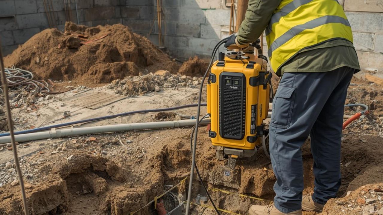
GPR scanning addresses the core challenge facing California construction: buried utilities are invisible until excavation begins. Ground penetrating radar provides subsurface imaging that detects metallic and non-metallic targets, reducing strike risk before crews break ground. The global ground penetrating radar market reached USD 457.32 million in 2025 and is expected to grow to USD 882.67 million by 2034, reflecting increasing demand for advanced detection capabilities. California's dense urban infrastructure, regulatory environment, and high excavation volumes make accurate utility mapping in LA projects particularly valuable.
Key Takeaways
GPR scanning uses radar-based imaging to identify subsurface utilities and estimate their depth. Understanding what is GPR and how does it work helps project teams evaluate detection methods for California infrastructure environments. The technology transmits electromagnetic pulses into the ground and analyzes reflected signals to create subsurface profiles. These profiles reveal both metallic and non-metallic targets that traditional methods might miss.
Ground penetrating radar delivers depth estimation and detection of both metallic and non-metallic targets in a single workflow. The global GPR market is growing at a 7.58% CAGR, outpacing the broader utility locator market growth rate. Systems typically detect targets to 3 meters depth, with some configurations reaching 5 meters depending on soil conditions. This depth range covers most buried utilities encountered during construction and infrastructure work.
Electromagnetic locating uses a transmitter and receiver workflow optimized for metallic line tracing. EM methods are inherently weaker for non-metallic PVC or HDPE utilities unless tracer wire is present. Comparing GPR vs EM locating technology for your project reveals that directional market data shows roughly 47% EM and 45% GPR adoption in 2024. GPR represents the fastest-growing technique segment, while electromagnetic field methods hold the largest public revenue share at 44.5%.
The global utility locator market was valued at USD 842.5 million in 2023 and is projected to reach USD 1.252 billion by 2030. Electromagnetic field technology represented 44.5% of global utility locator revenue in 2023, establishing it as the volume leader. The utility locator market is growing at a 6.1% CAGR over the forecast period. Subsurface utility engineering is a process combining multiple technologies rather than a single detection method.
The importance of utility mapping in construction becomes clear when examining California's damage statistics and project economics. Accurate subsurface data prevents costly strikes, schedule delays, and regulatory violations on infrastructure work. California construction contributed USD 158 billion to the state's GDP in 2024, creating a large base of excavation-intensive activity. This economic scale amplifies the financial impact of utility conflicts and damage events.
Underground congestion in urban California environments creates strike-prevention risk that threatens project schedules and budgets. Schedule risk from utility conflicts causes redesigns, change orders, and work stoppages that exceed the cost of mapping. Design uncertainty from poor utility records forces conservative engineering assumptions that increase project costs. Bay Area utility locating addresses these risks by providing verified subsurface intelligence before excavation begins.
Failure to use the 811 notification system contributed to nearly 38% of damages in California during 2023. This statistic demonstrates that preventable utility strikes remain a persistent problem across the state. Inaccurate data leads to damaged infrastructure, service outages, safety incidents, and regulatory exposure. Why utility locating is essential for construction operations becomes evident when damage costs are compared to mapping investments.
Compliance exposure in California's regulated environment creates legal and financial pressure to verify utility locations. State regulations require notification before excavation, but standard 811 responses may not provide engineering-grade accuracy. ASCE 38-02 standards establish quality levels for subsurface utility engineering that exceed basic locating requirements. Meeting these standards requires advanced detection methods and verification workflows that GPR scanning helps deliver.
General contractors and construction managers represent 52% of the decision-influencer mix for utility scanning purchases. Specialty contractors account for 25% of decision influence, followed by suppliers and services at 13%. Owners and developers hold 5% influence while architects, engineers, and designers represent 3% of the mix. This distribution shows that field-oriented professionals drive most technology adoption decisions.
Engineering project managers, construction superintendents, and public works directors prioritize accurate subsurface data for design and planning decisions. Utility operations managers focus on protecting network integrity and preventing third-party damage. Base civil engineers managing military installation infrastructure require compliance with federal standards. These roles share common priorities around strike prevention, regulatory compliance, and cost control.
Stakeholders want location tolerances better than 100 mm for critical utilities and infrastructure work. Daily field reports are used by 67% of California contractors, while 59% track time and 57% use field job information. Document sharing reaches 49% adoption, demonstrating demand for workflows that connect field capture to documentation. These priorities indicate that buyers value accuracy, documentation quality, and integration with existing construction management systems.
California 811 ticket volume rises from winter lows into stronger spring and summer patterns. A notable late-summer and early-fall peak appears, especially in northern California territory. Seasonal demand follows construction activity cycles, with utility mapping LA and Bay Area projects peaking during favorable weather months. Understanding these patterns helps contractors plan equipment purchases and service contracts around project schedules.
DigAlert covers Los Angeles, Orange, Riverside, San Bernardino, San Diego, Santa Barbara, Ventura, Imperial, and Inyo counties in Southern California. Through October 31, 2024, the combined proxy split showed 58.2% USA North territory and 41.8% DigAlert territory. Both regions represent significant demand centers, but for different operational reasons. Los Angeles concentrates high urban congestion, while the Bay Area combines urban density with extensive transportation infrastructure.
Dense urban settings such as Los Angeles, San Francisco, Oakland, and San Jose face greater buried-asset congestion and critical-facility adjacency. These conditions favor multi-method scanning, stronger documentation, and GIS-ready deliverables over basic locating. Lower-density suburban environments may accept basic EM locating unless project conditions justify advanced methods. Price sensitivity typically increases in suburban markets where excavation consequences are lower.
Northern California activity levels are comparable to or larger than Southern California based on 811 proxy measures. The Bay Area's urban utility environment creates similarly high-consequence conditions as Los Angeles despite geographic differences. Regional excavation patterns drive method selection, with dense corridors favoring integrated workflows and open areas accepting simpler approaches. Technology adoption follows consequence rather than geography alone.
Southern California projects contend with extensive transportation networks, high population density, and complex utility ownership patterns. Northern California faces similar density in urban cores but adds seismic considerations and varied terrain. Soil conditions differ between regions, affecting GPR performance and requiring site-specific method selection. Both regions share regulatory requirements but face distinct operational environments that influence scanning workflows.
Projects should select GPR when non-metallic utilities, depth information, or broader target detection outweigh cost considerations. GPR performance is sensitive to soil conditions, operator skill, and project fit rather than being universally superior. The technology is weaker in clay-rich soils, where electromagnetic methods may provide better metallic-utility detection. How GPR improves safety in excavation construction becomes clearest on projects where standard methods leave unacceptable blind spots.
Projects with unknown non-metallic lines, poor record quality, or congested utility environments benefit most from GPR capabilities. Sites where in-depth insight affects design decisions justify the higher cost and interpretation requirements. Complex urban corridors in Los Angeles and the Bay Area often present conditions where GPR adds material value. Projects requiring engineering-grade deliverables or GIS integration also favor advanced scanning methods.
Multi-channel GPR and time-domain electromagnetic induction were used together in Oregon DOT case studies to compensate for individual method weaknesses. Combined approaches allow teams to verify metallic targets with EM while using GPR for non-metallic detection. Engineering judgment, geophysics, surveying, and records research form an integrated workflow that improves confidence. This layered approach targets test holes more efficiently and reduces verification costs.
QL-A nondestructive exposure becomes necessary where engineering-grade vertical and horizontal accuracy is required for design advancement. Projects with high conflict probability, critical adjacencies, or liability exposure justify integrated workflows despite higher upfront costs. Utility mapping as a smart investment shows the strongest returns on dense infrastructure projects with significant redesign risk. Cloud storage, GIS-based 2D/3D visualization combined with field locating, creates persistent asset intelligence that outlives individual projects.
EM locator purchase costs approximately USD 5,000, or rental runs around USD 300 per week for basic systems. Utility GPR systems range from USD 14,000 to USD 100,000+, depending on channel count, mobility, and software capabilities. Integrated packages combining multiple technicians and methods cost around USD 3,360 per day for comprehensive coverage. Price segmentation reflects capability differences rather than simple equipment categories.
Budget-tier electromagnetic locating suits basic metallic utility work where project complexity remains low, and records are reliable. Mid-tier GPR systems serve firms needing broader detection without full corridor-scale mapping platforms or vehicle-mounted arrays. Premium hardware, including advanced GPR and integrated platforms, fits organizations requiring throughput, map-ready outputs, or broader capability sets. Premium service packages offer outsourcing options for complex projects where strike costs or redesign risks exceed daily rates.
Material costs, recession risk, and financing costs affect contractor purchasing decisions alongside equipment capabilities. Labor costs and workforce quality pressures make technologies that reduce crew error more attractive. Buyers increasingly recognize that the lowest price rarely proves optimal on high-consequence work where strikes trigger claims. The economic calculation shifts from equipment cost to total project risk when underground conditions threaten schedules or budgets.
Average savings of about 4.6% of total construction cost from subsurface utility engineering were documented across 71 highway projects. Typical SUE savings range from 10% to 15%, depending on project complexity and initial data quality. ROI reaches USD 12.23 for every USD 1.00 spent on SUE according to a later Purdue analysis. These returns come from avoiding unnecessary relocations, preventing damage events, and reducing redesign delays.
QL-A requires nondestructive exposure and yields the highest-confidence horizontal and vertical information for engineering applications. QL-B uses surface geophysical methods to determine the existence and horizontal position of utilities without excavation. GPR concrete scanning and subsurface work both rely on quality level frameworks to match method to confidence requirements. QL-A vertical plan data typically achieves about 15 mm vertical accuracy plus applicable horizontal survey precision.
ASCE 38-02 establishes quality level definitions that govern how accuracy is reported and verified in subsurface utility engineering. Stakeholder surveys across 85 valid responses identified accurate utility depth, accurate detection, and accurate location of critical utilities as top priorities. Industry standards require better than 100 mm tolerance for serious engineering applications, typically to 3 meters depth. Some projects demand 5 meters detection depth depending on the infrastructure type and design requirements.
The 71 highway projects analyzed in the Purdue study demonstrated that quality level selection directly impacts project outcomes and savings. Verification methods, including test holes, vacuum excavation, and nondestructive exposure, convert surface geophysics into engineering-grade certainty. Moving from QL-C records research through QL-B surface geophysics to QL-A exposure creates progressively higher confidence at increasing cost. Projects must match the quality level of investment to the consequences of being wrong about the utility position.
GPR performance depends on soil conditions, operator skill, and project fit rather than equipment specifications alone. How soil conditions affect GPR accuracy explains that clay-rich soils, high moisture content, and subsurface contamination degrade signal quality. Inexperienced skilled labor and workforce shortage were cited by 78% of contractors as a safety challenge affecting quality. Training requirements typically include 1-2 days for digital system transition and 1-2 weeks plus testing for additional device support.
GPR scanning has become essential for managing subsurface risk on California infrastructure work because it addresses detection blind spots that traditional methods miss. The combination of urban density, non-metallic utilities, and regulatory requirements creates demand for multi-method workflows that balance cost against consequence. Projects ranging from transportation corridors to municipal utilities benefit when scanning investments prevent strikes, reduce conflicts, and improve engineering confidence. Bess Utility Solutions provides ASCE 38-02 compliant utility mapping services across Los Angeles and Bay Area markets, helping project teams navigate California's complex underground environment with precision.
The most important insight for engineering project managers and construction superintendents is that utility scanning should be evaluated as risk management rather than overhead expense. Advanced detection methods pay for themselves through avoided damage, reduced redesign, and faster project delivery. When subsurface uncertainty threatens project success, investing in accurate utility intelligence becomes the most cost-effective decision available.
Bess Utility Solutions delivers ASCE 38-02 compliant GPR scanning and utility mapping services across Los Angeles, the Bay Area, and throughout California and Arizona. With 29 years of experience, CPUC certification, and 1,000+ satisfied clients, our team gives engineers and contractors the verified subsurface intelligence they need to design accurately, excavate safely, and keep projects on schedule.
Don't let unknown utilities become a costly problem on your next project. Contact Bess Utility Solutions today for a consultation and find out how our advanced detection services protect your timeline, your budget, and your crew.
Disclaimer:
All pricing information provided in this article is for general informational purposes only and may not reflect current rates. Actual costs can vary based on project scope, site conditions, and specific service requirements. For accurate pricing and a customized quote, please contact Bess Utility Solutions directly.


