Hayward, CA
Fresno, CA
Orange, CA
Sacramento, CA
Phoenix, AZ
Selecting a LIDAR scanning partner in California for utility projects requires evaluating technology capabilities, regulatory compliance, and deliverable quality. The right partner selection determines whether your project achieves millimeter-level accuracy, meets CPUC standards, and delivers actionable data within budget constraints. California's unique regulatory environment and diverse terrain demand providers with proven expertise in both airborne and terrestrial scanning systems. Understanding the technical differences between LIDAR categories and matching them to your specific California utility projects ensures you avoid costly rework and project delays.
Key Takeaways
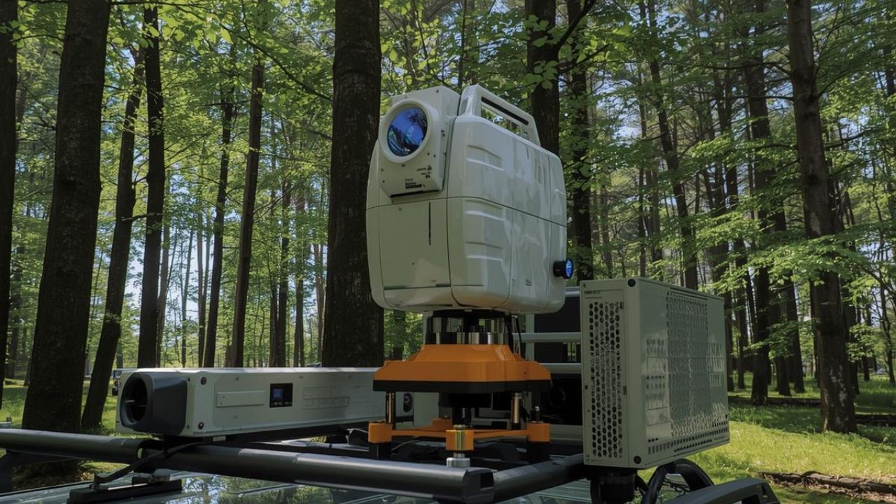
LIDAR stands for Light Detection and Ranging and measures distances using laser pulses to create precise 3D representations. This technology delivers millions of data points compared to approximately 1,000 points captured through traditional surveying methods. Traditional surveying produces 2D topographic maps while drone LIDAR generates comprehensive 3D point clouds, digital elevation models, and orthomosaic imagery. Utility projects require this level of detail to detect potential clashes before construction begins, preventing rework costs that can reach millions of dollars.
LIDAR systems emit rapid laser pulses that reflect off surfaces and return to the sensor, measuring time-of-flight to calculate distances. These measurements combine with GPS positioning and inertial measurement units to create georeferenced 3D point clouds with spatial accuracy. SLAM (Simultaneous Localization and Mapping) technology enables continuous data collection while the sensor moves through complex environments without GPS. RTK/PPK GPS integration provides high global accuracy essential for matching survey-grade control points and ensuring regulatory compliance.
Airborne and drone-based LIDAR systems currently capture 47% of the market share for commercial surveying applications. Terrestrial LIDAR holds 25% market share and serves projects requiring sub-centimeter precision for engineering documentation and structural analysis. Mobile LIDAR accounts for 15% market share with growing adoption for transportation corridors and urban infrastructure mapping. DJI Zenmuse L1 and L2 drone LIDAR systems represent affordable entry points ranging from $12,000 to $20,000 for budget-conscious utility providers.
California utility projects face strict CPUC regulations and wildfire mitigation requirements that demand comprehensive vegetation management and infrastructure documentation. Drone LIDAR completes 100-acre site surveys in 1-2 days compared to 10-14 days required for traditional surveying crews. This acceleration becomes essential when utility providers must inspect thousands of miles of transmission corridors under regulatory deadlines. The millions of data points captured enable clash detection analysis that identifies conflicts between proposed designs and existing infrastructure before construction mobilization.
Technology selection depends on project scale, required accuracy levels, terrain complexity, and deliverable specifications for California utility projects. Aerial mapping inspection systems excel at covering extensive transmission corridors, while terrestrial scanners provide engineering-grade precision for substations and critical structures. Cost considerations and timeline requirements further influence whether airborne, terrestrial, or mobile systems deliver optimal value.
Large acreage surveys and linear corridor mapping across difficult terrain require drone or airborne LIDAR to achieve practical field completion. A 100-acre utility site survey requires only 1-2 field days using drone LIDAR versus 10-14 days with traditional crews. This service comparison shows drone LIDAR delivers 80-90% time savings over conventional surveying methods.
Choose airborne LIDAR when you need to survey extensive transmission corridors spanning hundreds of acres. Choose terrestrial LIDAR when your project demands engineering-grade precision for critical structures. Airborne systems deliver lower point density compared to terrestrial methods and remain highly sensitive to weather conditions. Regulatory airspace restrictions in urban California regions may require special FAA waivers for operations over people or beyond the visual line of sight.
Projects demanding sub-centimeter accuracy for structural engineering, as-built verification, or critical infrastructure documentation require terrestrial LIDAR capabilities. Terrestrial laser scanning achieves 1-3mm accuracy levels essential for BIM model development and LADBS-ready deliverables in Los Angeles projects. This precision comes with tradeoffs, including slow data collection requiring multiple scanner setups and labor-intensive field operations.
Choose terrestrial scanning when you need millimeter-level accuracy for structural analysis. Choose mobile LIDAR when your priority is rapid data collection for transportation corridors. Line-of-sight limitations restrict terrestrial coverage in heavily vegetated areas where drone systems capture canopy and ground data simultaneously.
Mobile LIDAR mapping achieves 5-20mm accuracy sufficient for transportation corridors, streetscape documentation, and rapid facility mapping. These systems collect continuous data while moving, dramatically accelerating field operations compared to static terrestrial scanning with multiple setups. Mobile LIDAR sacrifices precision compared to terrestrial systems, delivering 5-20mm accuracy versus 1-3mm for tripod-mounted scanners.
SLAM drift accumulates over long distances without GPS-based control points, requiring careful project planning and quality control verification. Choose mobile LIDAR when you need continuous corridor mapping at moderate accuracy levels. Choose terrestrial systems when engineering precision outweighs speed considerations for your California utility projects.
Utility providers and engineering firms prioritize data accuracy and precision, with 88% ranking this as their primary decision factor. Total cost of ownership considerations influence 76% of purchasing decisions as organizations evaluate equipment investment versus outsourced service models. Speed of data collection drives 72% of California utility projects, where regulatory deadlines and seasonal weather windows demand rapid mobilization.
Data accuracy and precision lead consumer priorities, with 88% of utility providers requiring millimeter-level verification for critical infrastructure projects. Total cost of ownership ranks second at 76% as organizations analyze equipment depreciation, training costs, and software licensing against outsourced services. The speed of data collection influences 72% of project decisions, where traditional surveying timelines create unacceptable schedule delays. Service quality and support considerations affect 58% of buyers who value responsive technical assistance and reliable field operations.
North America captures 38% of the global LIDAR market share in 2025, driven by infrastructure modernization and autonomous vehicle development. The North American market projects growth from $1.25 billion in 2025 to $4.8 billion by 2030, representing 30.9% CAGR. California leads regional adoption due to stringent environmental regulations, extensive utility networks, and active commercial development across major metropolitan areas.
Global LIDAR market valuation ranges from $2.89 billion to $3.11 billion in 2025 across commercial, automotive, and industrial applications. Market projections estimate growth to $12.77 billion to $17.80 billion by 2034-2035 across all technology categories and geographic regions. California utility projects represent a significant market share within North America due to mandatory vegetation management programs and infrastructure replacement initiatives.
Partner evaluation begins with clearly defining project scope boundaries, accuracy requirements, and specific deliverable formats required for regulatory compliance. Technology fleet diversity matters because mixed-environment California utility projects may require both aerial corridor mapping and terrestrial substation documentation. Surveying mapping experience with CPUC standards and utility-specific workflows ensures providers understand safety protocols and clearance documentation requirements.
Sub-centimeter accuracy projects involving structural engineering analysis, foundation surveys, or critical equipment placement require terrestrial LIDAR capabilities. Large acreage sites, transmission corridors, or distribution network mapping spanning multiple miles demand drone or airborne LIDAR for practical completion. Understanding whether deliverables must meet LADBS standards for Los Angeles projects or CPUC compliance for utility infrastructure determines necessary precision levels. Budget constraints and timeline requirements influence whether outsourced services or equipment investment delivers superior return on investment.
BIM (Building Information Modeling) compatibility ensures point cloud data integrates seamlessly into Autodesk Revit or other design platforms used by engineering teams. LADBS-ready deliverables meeting Los Angeles Department of Building and Safety standards require specific formatting and quality control procedures for municipal approval. Scan-to-BIM conversion transforms raw point clouds into intelligent 3D models with embedded object properties and clash detection capabilities.
Providers must deliver actionable data, including classified point clouds, bare-earth digital elevation models, and construction-ready CAD drawings rather than unprocessed datasets. Choose a LIDAR scanning partner who can demonstrate proficiency with your specific software platforms. Choose providers with proven LADBS experience when working on Los Angeles municipal projects.
California Public Utilities Commission (CPUC) regulations govern utility corridor surveys and vegetation management documentation, requiring specific quality standards and reporting formats. FAA Part 107 certification represents the minimum requirement for commercial drone operations, with additional waivers needed for urban environments. Certifications demonstrate professional competence and insurance coverage essential for liability protection on California utility projects.
Operations over people or beyond the visual line of sight demand specific FAA waivers that many providers lack for urban California environments. Choose partners with active FAA certifications and urban operation waivers when your project involves populated areas. Choose CPUC-certified providers when working on regulated utility infrastructure requiring compliance documentation.
Equipment investment decisions require analyzing annual project volume, required accuracy levels, and internal technical expertise for data processing and quality control. Budget drone LIDAR systems start at $12,000-$20,000, while mid-range solutions cost $20,000-$50,000 and premium survey-grade systems exceed $50,000-$150,000. Traditional surveying costs $15,000-$20,000 for 100-acre sites compared to $6,500-$9,000 for equivalent drone LIDAR services delivered by specialized providers.
Budget and entry-level drone LIDAR systems, including DJI Zenmuse L1/L2 models, range from $12,000 to $20,000 for basic utility corridor mapping. Mid-range drone LIDAR platforms like ROCK R2A and GreenValley LiAir cost $20,000-$50,000 and deliver improved accuracy and point density. Premium drone LIDAR exceeds $50,000-$150,000 for survey-grade systems manufactured by Riegl and other specialized providers serving demanding engineering applications. Budget terrestrial LIDAR starts at $35,000-$38,900, while mid-range terrestrial systems cost $38,900-$73,000 for comprehensive scanning capabilities.
Traditional surveying crews require 2-3 personnel for field operations, while drone LIDAR operates with 1 pilot and 1 visual observer. Field time for 100-acre traditional surveys extends 10-14 days compared to 1-2 days for equivalent drone LIDAR data collection. This time reduction directly translates to labor cost savings and faster project completion for California utility projects. Traditional surveying delivers approximately 1,000 data points and 2D topographic maps, while drone LIDAR captures millions of points. Subsurface 3D mapping integration with LIDAR enables comprehensive utility documentation combining surface terrain with underground infrastructure locations.
Organizations exceeding 500 acres annually in survey needs typically achieve 8-12 month ROI with in-house mid-range drone LIDAR investments. Outsourcing remains recommended for projects under 500 acres annually, where service costs range from $6,500-$9,000 per 100-acre survey. Basic drone flight services cost $1,000-$2,500 per day for simple aerial photography and preliminary mapping without survey-grade accuracy. Comprehensive survey-grade LIDAR services reach up to $12,000 per day, including advanced processing, classification, and engineering-ready deliverables.
Choose in-house equipment when your annual survey volume exceeds 500 acres, and you have technical staff for data processing. Choose outsourced services when project volumes are sporadic or when you lack internal processing expertise.
Real-world California utility projects demonstrate LIDAR's practical advantages in challenging terrain, regulatory compliance, and accelerated timelines for critical infrastructure. PG&E gas transmission locating projects showcase the integration of multiple technologies for comprehensive subsurface and surface documentation across extensive pipeline networks. Commercial development applications in Los Angeles and San Francisco demonstrate scan-to-BIM workflows that eliminate design conflicts before construction mobilization.
A 15-acre hilltop survey with 500-foot elevation differences across muddy coastal terrain required rapid power line inspection without utility disruptions. The Surefire/ROCK LIDAR partnership deployed DJI M300 RTK drones equipped with ROCK R2A LIDAR sensors for complete data capture. Field operations completed in a fraction of traditional survey time while maintaining error-free accuracy and full CPUC regulatory compliance.
Remote access challenges and steep terrain made traditional ground crews impractical, while helicopter surveys would have required costly utility outages. This case demonstrates how proper LIDAR scanning partner selection enables project completion under challenging conditions that would otherwise create delays or safety risks.
Commercial developers in Los Angeles utilize LIDAR scan-to-BIM workflows to create LADBS-ready deliverables that accelerate municipal approval processes. Converting point clouds into intelligent 3D Revit models enables clash detection analysis, identifying conflicts between architectural designs and existing building systems. Site analysis acceleration cuts initial engineering timelines by up to 50% compared to traditional surveying and manual CAD drafting.
As-built documentation for renovation projects ensures millimeter-level accuracy essential for structural engineering calculations and permit submissions. Choose scan-to-BIM services when your project requires integration with architectural design software. Choose traditional LIDAR deliverables when raw point cloud data meets your documentation requirements.
California utility providers face mandatory vegetation management under CPUC regulations requiring comprehensive documentation of clearance distances around transmission infrastructure. Airborne LIDAR captures detailed canopy structure and ground elevation, enabling precise calculation of conductor-to-vegetation clearances across thousands of corridor miles. The future of utility locating integrates AI-powered analysis of LIDAR data to automatically identify vegetation encroachment risks.
Seasonal weather windows demand rapid data collection that only aerial LIDAR systems can achieve across California's extensive utility networks. Choose aerial LIDAR for vegetation management programs spanning large corridor networks. Choose terrestrial methods when documenting specific high-risk zones requiring engineering-grade precision.
Successful California utility projects require LIDAR scanning partners with proven technology capabilities, regulatory compliance expertise, and demonstrated track records on similar infrastructure applications. Technology selection between airborne, terrestrial, and mobile LIDAR depends on site scale, precision requirements, terrain complexity, and timeline constraints. Service comparison across multiple providers reveals differences in technology fleets, processing capabilities, and regulatory certifications that directly impact project success.
At Bess Utility Solutions, we bring 29 years of California utility project experience to LIDAR integration with comprehensive subsurface documentation and surface mapping capabilities. Our CPUC certification and ASCE 38-02 compliant processes ensure regulatory alignment across municipal and utility infrastructure projects statewide. Contact us today to discuss your specific requirements and receive a detailed project proposal that delivers the accuracy and responsiveness your California utility project demands.


