Hayward, CA
Fresno, CA
Orange, CA
Sacramento, CA
Phoenix, AZ
California utility developers increasingly face decisions about LIDAR vs traditional surveying as infrastructure demands intensify. The state's wildfire prevention mandates, aging grid infrastructure, and regulatory requirements drive technology adoption across urban and rural service territories. Developer decision-making now incorporates accuracy metrics, cost comparisons, and compliance requirements specific to California utility projects.
Key Takeaways
LIDAR represents a remote sensing technology that measures distances using laser pulses to create three-dimensional point clouds. Traditional surveying encompasses manual field measurements, total station theodolites, and conventional photogrammetry techniques. Both surveying techniques serve distinct purposes within utility infrastructure planning, though LIDAR adoption accelerates as costs decrease and regulatory requirements increase.
The fundamental distinction lies in data acquisition speed, spatial coverage, and precision characteristics. LIDAR captures millions of data points per second across extensive areas, while traditional methods provide highly accurate measurements at discrete locations.
LIDAR employs Light Detection and Ranging principles to measure distances by calculating laser pulse travel time. Sensors emit rapid laser pulses that reflect off surfaces, with timing differences converted into precise distance measurements. This process generates dense point clouds representing terrain, vegetation, and infrastructure features with centimeter-level accuracy.
Modern LIDAR systems integrate GPS and inertial measurement units to georeference each laser return accurately. Processing software converts raw point cloud data into digital elevation models and asset inventories. California utility applications benefit from aerial mapping inspection capabilities that reduce field time while improving data completeness.
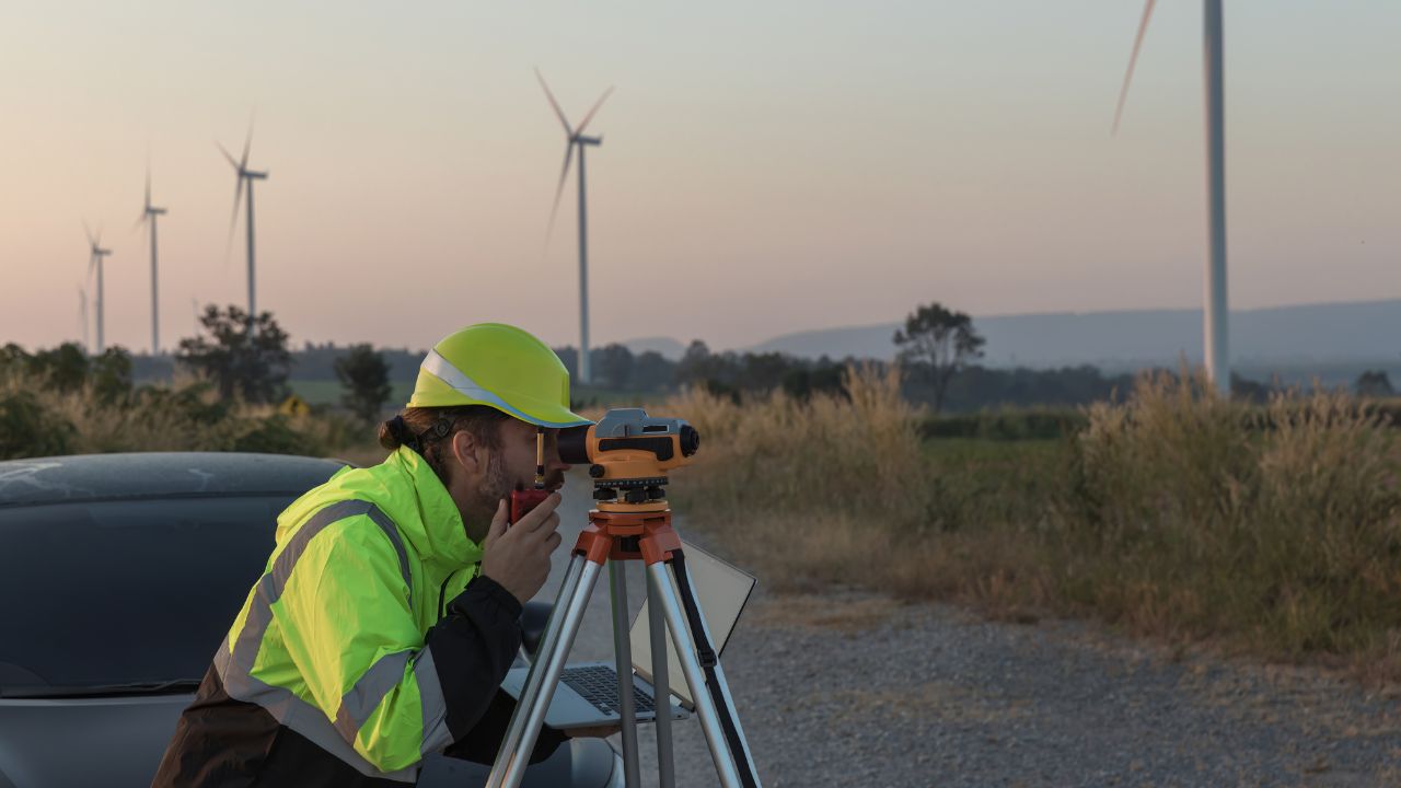
Traditional surveying techniques rely on direct ground measurements using total stations, GPS receivers, and leveling equipment. Surveyors establish control networks through physical monuments and measure angles, distances, and elevations to map infrastructure features. These methods require extensive field time but deliver millimeter-level precision for critical engineering applications.
Photogrammetry uses overlapping aerial photographs to create topographic maps and orthorectified imagery. Manual field surveys remain essential for boundary determination, legal descriptions, and situations requiring licensed surveyor certification.
Drone LIDAR achieves vertical precision of 0.4-1.2 inches compared to photogrammetry's 0.8-1.6 inches, providing superior accuracy for vegetation clearance analysis. Cost differences prove substantial, with drone LIDAR reducing survey expenses by 30-50% versus manned aircraft operations.
Traditional surveying maintains advantages for legal boundary work and projects requiring licensed professional certification under state law. LIDAR excels at rapid area coverage and penetrating vegetation canopies to map ground surfaces and infrastructure features.
Choose traditional surveying if you need legal boundary documentation, millimeter precision for structural engineering, or licensed professional certification for regulatory compliance.
Choose LIDAR if you need rapid area coverage, vegetation penetration capabilities, or cost-effective mapping across extensive utility corridors exceeding 100 acres.
Accurate surveying directly prevents catastrophic failures, regulatory violations, and public safety incidents across California's electric grid. Infrastructure mapping identifies clearance violations, structural deficiencies, and vegetation encroachment before conditions escalate. California utility projects face unique challenges from wildfire risks, seismic activity, and aging infrastructure requiring proactive condition assessment.
Regulatory compliance depends on documented clearance verification, asset condition records, and risk mitigation evidence. Survey accuracy affects liability exposure, insurance costs, and public trust during heightened wildfire awareness.
Wildfire ignition from vegetation encroachment remains the primary risk driving surveying investment across California's utility networks. LIDAR-based vegetation encroachment detection identifies trees approaching power lines before contact occurs, enabling preventive tree removal. Southern California Edison deploys helicopter-mounted LIDAR for wildfire prevention across its 1.6 million tree monitoring program, demonstrating large-scale risk reduction capabilities.
AI-powered vegetation management systems analyzing LIDAR data can reduce outage risks by up to 70% through predictive maintenance scheduling. Accurate clearance measurements enable utilities to prioritize trimming operations based on actual encroachment risk rather than fixed schedules. Utility locating for emergency response and risk mitigation becomes more effective when supported by comprehensive spatial data documenting infrastructure conditions.
Power line outages from conductor sag create service disruptions and ignition risks during high-temperature operating conditions. Surveying techniques measure actual sag conditions under varying load scenarios, enabling utilities to identify circuits approaching clearance limits. LIDAR-based sag analysis captures spatial relationships between conductors and underlying terrain across entire circuits in a single survey mission.
Structural failures from equipment degradation require condition assessment surveys documenting pole tilt, insulator deterioration, and hardware corrosion. Terrestrial laser scanning provides millimeter-accurate documentation of substation equipment and critical infrastructure requiring precise dimensional analysis for retrofit planning.
California WERK initiative represents a $30 million state investment in statewide LIDAR mapping for wildfire risk assessment. WERK processed over 100 million acres of LIDAR data to create consistent vegetation and forest condition maps supporting utility planning. This government-led effort establishes baseline datasets that private utilities integrate into compliance reporting and risk mitigation programs.
State regulations mandate vegetation clearance verification, infrastructure condition documentation, and proactive hazard identification for investor-owned utilities. CPUC oversight requires evidence-based maintenance programs supported by accurate spatial data documenting clearance measurements and asset conditions.
Utility developers evaluate LIDAR adoption based on quantifiable priorities, ranking accuracy, risk reduction, and cost considerations. Survey data quality directly impacts engineering decisions, maintenance scheduling, and regulatory compliance outcomes. California's competitive utility market rewards technology investments that demonstrate measurable safety improvements and operational cost reductions.
Accuracy priority scores reach 95% importance among utility decision makers evaluating surveying technologies for infrastructure projects. Risk reduction priority follows at 90% importance, reflecting wildfire liability concerns and public safety mandates. Vertical precision requirements differ by application, with vegetation management tolerating centimeter-level accuracy while substation design demands millimeter precision. Reducing utility strikes and the importance of accurate buried line detection demonstrate how accuracy directly prevents damage incidents and safety violations.
Cost priority receives an 88% importance score as utilities balance infrastructure investment against ratepayer affordability constraints. Speed priority scores 82% importance, reflecting competitive pressures to complete projects faster and minimize service disruptions. Coverage priority ranks at 75% importance since California's extensive service territories require efficient area mapping capabilities.
Integration priority scores 70% importance as utilities require seamless data flow between surveying systems and existing GIS platforms. Subsurface 3D mapping integration enables utilities to combine above-ground LIDAR data with underground infrastructure records for comprehensive project planning.
LIDAR deployment patterns across California reflect regional differences in infrastructure density, wildfire risk, and utility company priorities. Urban areas adopt LIDAR faster due to complex infrastructure requiring frequent condition assessments. Rural regions accelerate adoption driven by wildfire prevention mandates and vegetation management requirements across remote service territories.
Los Angeles and Southern California claim 28% adoption share, driven by Southern California Edison's extensive wildfire mitigation programs. The San Francisco Bay Area follows with 25% adoption share, reflecting Pacific Gas and Electric's infrastructure modernization efforts. San Diego represents 22% adoption share supported by comprehensive system-wide mapping initiatives. The Central Valley accounts for 12% adoption share with growing investment in agricultural interface monitoring.
Urban areas demonstrate 72% adoption rates with dense infrastructure requiring frequent condition assessments and clearance verification documentation. Rural areas show 45% adoption rates, accelerating through wildfire prevention mandates requiring vegetation monitoring across remote corridors.
LIDAR applications across utility infrastructure focus on corridor mapping, vegetation management, asset inspection, and risk assessment activities. Each application category requires different accuracy specifications, update frequencies, and data processing workflows.
Corridor mapping represents 38% of utility applications, with power line corridor mapping delivering conductor sag analysis and clearance verification. Vegetation encroachment accounts for 35% of utility applications as California's wildfire crisis intensifies regulatory scrutiny and liability exposure. Asset inspection represents 18% of utility applications focused on condition assessment and structural integrity verification. Risk assessment accounts for 12% of applications, combining LIDAR terrain data with vegetation fuel models to predict wildfire behavior. Vacuum excavation potholing complements LIDAR surveys by verifying subsurface utility locations before construction activities.
System selection depends on accuracy requirements, coverage needs, and site accessibility constraints. Drone-based LIDAR suits extensive area mapping and vegetation monitoring across remote or difficult terrain inaccessible to ground crews. Terrestrial LIDAR serves applications requiring millimeter precision for structural analysis and detailed facility documentation. Mobile LIDAR provides efficient urban infrastructure mapping, capturing street-level assets during normal vehicle operations without traffic disruption.
Choose drone-based LIDAR if you need extensive area coverage exceeding 500 acres, vegetation canopy penetration for ground surface mapping, or reduced helicopter costs while improving safety through reduced manned flight hours. Drone-based LIDAR adoption grows at 20% annually as equipment costs decline and regulatory frameworks mature. Modern drone systems achieve vertical precision of 0.4-1.2 inches, meeting engineering requirements for most utility applications. Equipment costs range from $12,430 to $150,000+, making professional drone LIDAR systems accessible to mid-sized utility contractors.
Choose terrestrial LIDAR if you need millimeter precision for substation design, structural analysis requiring bolt pattern documentation, or detailed as-built conditions for retrofit planning. Terrestrial LIDAR accuracy of 1-3 mm suits engineering tasks requiring extreme precision. Static scanning positions enable higher point densities than mobile or aerial platforms across limited survey areas. Equipment costs of $35,000 to $80,000+ reflect precision capabilities exceeding most utility corridor mapping requirements.
Choose mobile LIDAR if you need urban infrastructure mapping without lane closures, street-level data collection including pole locations and transformer positions, or cost-effective solutions for routine infrastructure documentation. Mobile LIDAR accuracy of 5-20 mm provides sufficient precision for urban infrastructure mapping and asset inventory applications. Mobile systems costing $10,500 to $60,000 offer cost-effective solutions for routine infrastructure documentation.
LIDAR systems require higher initial investment than traditional surveying equipment but deliver lower per-acre costs across large projects. Total cost comparisons must account for data acquisition speed, processing requirements, and staffing needs. California utility projects benefit from LIDAR's reduced field time, minimizing traffic control costs and safety risks to survey crews.
Drone and UAV systems range from $12,430 for entry-level units to $150,000+ for survey-grade platforms with advanced sensors. Mobile systems cost $10,500 to $60,000, depending on sensor specifications and vehicle integration requirements. Terrestrial systems command $35,000 to $80,000+, reflecting precision capabilities and long-range measurement specifications. Helicopter systems represent premium investments at $50,000 to $250,000+ justified by extensive area coverage and operational efficiency.
Software licensing costs $2,000 to $15,000 annually for point cloud processing, feature extraction, and data management platforms. Advanced analytics, including AI-powered classification and automated reporting, command premium pricing. Maintenance expenses include sensor calibration, equipment repairs, and replacement parts, affecting multi-year ownership costs.
Mapping-as-a-Service models lower entry barriers by 40-60%, eliminating equipment acquisition and software licensing costs. Subscription services provide data deliverables without requiring in-house processing expertise or capital equipment investment. Pay-per-use pricing aligns costs with project needs, avoiding idle equipment during seasonal demand fluctuations.
Choose Mapping-as-a-Service if you have periodic survey needs under 5000 acres annually, limited in-house technical expertise for point cloud processing, or pilot programs testing LIDAR capabilities before capital investment.
Choose equipment ownership if you have continuous survey needs exceeding 10,000 acres annually, established GIS workflows requiring data integration control, or specialized applications requiring custom sensor configurations.
LIDAR technology transforms California utility operations through improved accuracy, reduced costs, and enhanced safety across infrastructure planning and maintenance activities. The comparison between LIDAR vs traditional surveying demonstrates clear advantages for area coverage, vegetation penetration, and data acquisition speed, supporting wildfire prevention mandates.
California utility projects benefit from multiple LIDAR platform options tailored to specific accuracy requirements and operational constraints. Developers must evaluate technology selections based on accuracy priorities, regulatory compliance needs, and integration requirements with existing asset management systems. Regional adoption patterns reflect infrastructure density, wildfire exposure, and utility company technology strategies shaping investment decisions.
California's regulatory environment and wildfire risks will continue driving LIDAR adoption across utility sectors during the coming years. Technology improvements promise further cost reductions and accuracy enhancements, making LIDAR accessible to smaller utilities and contractors. Strategic deployment of drone, terrestrial, and mobile systems enables utilities to optimize surveying techniques for specific applications while controlling total ownership costs.
LIDAR technology transforms California utility operations through improved accuracy, reduced costs, and enhanced safety across infrastructure planning and maintenance activities. The comparison between LIDAR vs traditional surveying demonstrates clear advantages for area coverage, vegetation penetration, and data acquisition speed, supporting wildfire prevention mandates. California utility projects benefit from multiple LIDAR platform options tailored to specific accuracy requirements and operational constraints.
At Bess Utility Solutions, we combine advanced LIDAR capabilities with comprehensive subsurface utility engineering services to support your California infrastructure projects. Our team delivers precise corridor mapping, vegetation management analysis, and asset inspection solutions that meet California's rigorous regulatory requirements. Contact us today to discuss how our surveying expertise can enhance your utility project outcomes and ensure compliance with state wildfire prevention mandates.


