Hayward, CA
Fresno, CA
Orange, CA
Sacramento, CA
Phoenix, AZ
California construction teams manage underground utilities and the congestion they create, producing utility strike risk, project delays, and compliance exposure on every excavation project. The global utility locator market reached USD 842.5 million in 2023, with ground penetrating radar growing faster than electromagnetic methods as detection complexity increases across dense urban corridors.
California contractors contributed USD 158 billion to the state’s GDP in 2024, supporting 922,400 workers across 95,800 establishments. Failure to use California’s 811 notification system contributed to nearly 38% of utility strikes and damages in 2023, making technology selection a direct damage prevention measure rather than a simple equipment purchase.
Key Takeaways
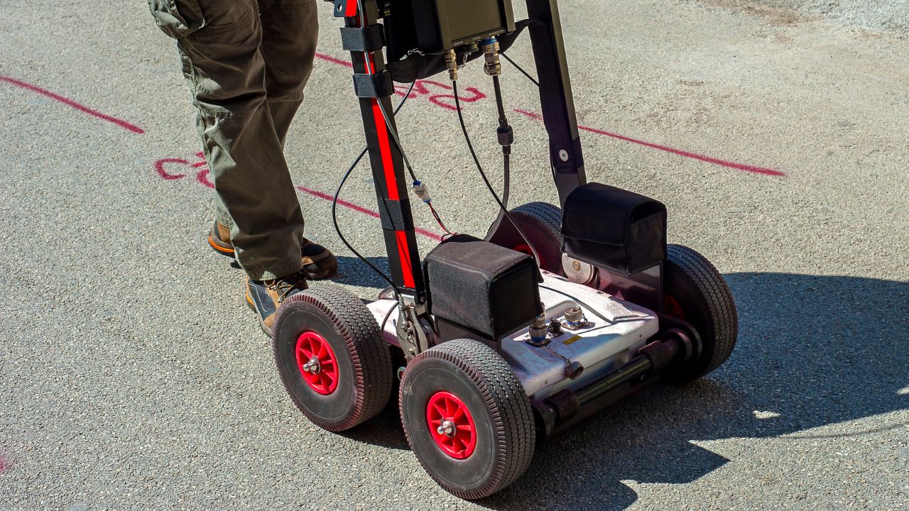
Electromagnetic locating and GPR represent the two dominant field methods for subsurface utility detection in California construction. Each technology operates on fundamentally different physical principles, creating distinct performance profiles that influence project outcomes.
Electromagnetic locating uses a transmitter to induce current in metallic lines, then detects the resulting field with a receiver. This frequency-based detection workflow requires conductive targets or the ability to insert a sonde or tracer wire into non-metallic lines.
The method represented 44.5% of global utility locator revenue in 2023, making it the largest disclosed technique segment. Electromagnetic field detection remains effective for gas lines, water mains, power cables, and telecommunications infrastructure containing metallic components.
GPR uses high-frequency radio waves to create subsurface images, enabling depth estimation and detection of both metallic and non-metallic targets. GPR technology and innovation continue advancing through multi-channel systems, GNSS integration, and real-time visualization software.
The global GPR market was valued at USD 457.32 million in 2025 and is expected to reach USD 882.67 million by 2034. This 7.58% CAGR confirms GPR as the fastest-growing advanced detection method in utility mapping applications.
EM locating delivers strong performance on metallic utilities but struggles with PVC and HDPE unless tracer wire exists. GPR detects both metallic and non-metallic targets while providing depth context that electromagnetic methods cannot capture independently.
GPR is the fastest-growing technique segment, while EM maintains the largest disclosed technique share at 44.5%. This market split reflects EM's mature adoption base and GPR's expanding relevance in complex subsurface environments.
California's dense infrastructure, active construction economy, and regulatory environment create unusually high demand for accurate utility detection. Strike prevention, compliance documentation, and schedule certainty drive technology adoption across public works, transportation, and private development projects.
California's Underground Safety Board reported that failure to use the 811 notification system contributed to nearly 38% of damages in 2023. This statistic directly ties scanning demand to preventable risk rather than optional precaution.
DigAlert covers Los Angeles, Orange, Riverside, San Bernardino, San Diego, Santa Barbara, Ventura, Imperial, and Inyo counties. USA North serves the Bay Area and northern California, with combined 2024 activity showing 58.2% northern territory volume and 41.8% DigAlert volume.
Subsurface utility engineering delivers an ROI of USD 12.23 for every USD 1.00 spent on advanced mapping workflows. This return emerges from avoided relocations, reduced redesign cycles, eliminated claims, and prevented damage events.
Analysis of 71 highway projects documented average savings of about 4.6% of total construction cost through better utility information. The importance of utility locating in construction projects extends beyond strike prevention to include design confidence and conflict resolution before excavation begins.
California construction contributed USD 158 billion to the state's GDP in 2024, supporting 922,400 workers as of August 2024. Private nonresidential spending reached USD 34 billion in 2023, while state and local construction spending totaled USD 46 billion.
California maintained 95,800 construction establishments in early 2024, creating sustained demand for utility scanning services. Seasonal ticket volume rises from winter lows into stronger spring and summer patterns, with notable late-summer and early-fall peaks.
Field performance differs significantly between EM and GPR based on utility type, soil conditions, depth, and operator skill. California contractors selecting between these technologies must understand both capabilities and limitations in real project environments.
EM locating proves highly effective for metallic utilities, delivering fast results at lower equipment costs than GPR alternatives. Electromagnetic locators vs GPR for finding buried power lines depends primarily on whether the target infrastructure contains conductive components or tracer wire.
The method becomes inherently weaker for non-metallic PVC or HDPE unless tracer wire is present or a sonde can be inserted. This limitation creates unacceptable residual risk in mixed utility environments where private utilities—including non-metallic water, sewer, or conduit systems—exist alongside metallic infrastructure.
GPR performance depends on soil conditions, moisture content, utility depth, target diameter, and operator interpretation skill. Clay-rich soils attenuate radar signals, reducing detection range and target clarity compared to sandy or gravelly conditions.
GPR carries higher equipment and service costs, with the probability of success varying unless project conditions are favorable. How GPR improves safety in excavation construction depends on matching technology capabilities to site-specific subsurface characteristics and project accuracy requirements.
Combined SUE workflows integrate multiple field methods, records research, survey control, quality levels, and verification planning into a single process. The SHRP2 Oregon DOT case study used multi-channel GPR and time-domain electromagnetic induction together to compensate for each method's weaknesses.
Combined workflows require a higher upfront cost and more coordination effort than single-method approaches. However, this investment delivers stronger engineering-grade outputs, reduced conflict risk, and better ROI on complex or high-consequence projects.
California buyers evaluate utility locating technology across four distinct price tiers, each corresponding to different capability levels and project requirements. Understanding this tier structure helps contractors match investment to project risk and documentation needs.
Budget EM locators cost around USD 5,000 for purchase or USD 300 per week for rental. Mid-tier utility GPR systems range from USD 14,000 to USD 30,000, providing broader target detection without full corridor-scale mapping capabilities.
Premium hardware, including advanced GPR and integrated platforms, costs USD 30,000 to USD 100,000 or more. Service models combining two-technician teams with equipment can run approximately USD 3,360 per day for integrated mapping workflows.
California's construction decision-maker mix includes 52% general contractors and construction managers, 25% specialty contractors, 13% suppliers and services, 5% owners and developers, and 3% architects, engineers, and designers. This contractor-led audience prioritizes accuracy, safety, and documentation over the lowest price on high-consequence work.
Current digital adoption shows 67% of contractors using daily field reports, 59% tracking time digitally, 57% accessing field job information, 49% sharing documents electronically, and 22% managing compliance reporting. These patterns support growing demand for software-integrated mapping platforms that connect field capture to documentation and project coordination.
Software platforms integrate cloud storage, GNSS positioning, 2D and 3D visualization, map overlay capabilities, and digital utility records into unified systems. These platforms depend on field data quality, requiring proper equipment operation and interpretation to deliver value.
California-focused case studies show staff can transition to digital utility mapping systems with 1-2 days of training. Additional device support integration typically requires 1-2 weeks plus testing, making adoption more feasible than legacy perception suggested.
California contractors operate in an environment where accuracy failures, safety incidents, and compliance gaps carry severe consequences. Project managers and engineers consistently rank accuracy and depth confidence above equipment cost when selecting utility locating methods.
Stakeholders want location tolerances better than 100 mm horizontally, usually to 3 meters depth, and sometimes to 5 meters. QL-A vertical plan data typically achieves about 15 mm vertical accuracy when combined with appropriate horizontal survey and mapping precision.
These accuracy levels require more than surface geophysics alone in many cases. The utility locating workflow of locate, mark, verify, and excavate ensures that confidence levels match project requirements before crews break ground.
SUE is a process rather than a single technology, encompassing field methods, quality levels, and verification protocols. QL-B uses surface geophysical methods to determine the existence and horizontal position of utilities, while QL-A requires nondestructive exposure to yield the highest-confidence horizontal and vertical information.
California's 38% damage contribution from 811 notification failures creates direct liability exposure and schedule risk. Why utility locating is essential for construction projects extends beyond regulatory compliance to include workforce safety, service continuity, and community impact during excavation activities.
Advanced utility mapping delivers an ROI of USD 12.23 for every USD 1.00 spent on SUE across documented projects. This return emerges from avoided utility relocations, eliminated design conflicts, reduced change orders, prevented project delays, and prevented damage events.
Highway project analysis documented average savings of about 4.6% of total construction cost when better utility information informed design and excavation planning. These savings become more significant as project scale, complexity, and urban density increase across California's major metropolitan corridors.
Technology selection should begin with project consequence rather than equipment preference or initial cost. The correct question is not which tool costs less, but rather what level of utility certainty the project requires and what financial and safety risk being wrong creates.
Project complexity drives the decision between basic locate capability, non-metallic detection capability, combined field confidence, and digital deliverables. Simple excavation around mostly metallic infrastructure with good records may justify EM locating as commercially sufficient.
Projects involving unknown non-metallic lines, poor records, congested utilities, or high public consequences require stronger detection and documentation capabilities. GPR vs EM locating technology for your project depends primarily on subsurface uncertainty, strike consequence, and accuracy requirements rather than equipment availability alone.
EM locating suffices when target utilities are metallic, records are reliable, project complexity is low, and excavation risk is moderate. This approach provides fast, cost-effective detection for each metallic utility line including water mains, gas lines, power cables, and telecommunications infrastructure containing conductive components. However, private utility locating for non-metallic assets requires GPR or combined methods.
GPR or combined workflows become necessary when projects include non-metallic targets, require depth information for design purposes, operate in congested corridors, or carry severe consequences for strikes. Combined SUE approaches deliver the strongest ROI on dense urban projects where redesign, relocation, or damage costs dwarf the incremental investment in better subsurface intelligence.
Software platforms integrate cloud storage, GNSS positioning, 2D and 3D visualization, map overlay, and digital utility records into persistent assets. These capabilities transform temporary field locates into detailed utility maps and long-term infrastructure intelligence that supports design coordination, permitting, and future maintenance activities for all underground utilities.
Digital platforms require proper field-data quality to deliver value, meaning equipment selection and operator skill remain foundational. However, once captured properly, digital utility information supports collaboration across design teams, field crews, inspectors, and asset managers throughout the project lifecycle.
California's regional variations in utility density, construction activity, and subsurface conditions influence technology preferences across the state. Los Angeles, the Bay Area, and other urban centers show different adoption patterns than suburban or rural environments.
DigAlert covers Los Angeles, Orange, Riverside, San Bernardino, San Diego, Santa Barbara, Ventura, Imperial, and Inyo counties, serving California's southern excavation market. USA North serves the Bay Area and broader northern California territory, with combined 2024 activity showing 58.2% northern volume and 41.8% DigAlert volume.
Both regions represent high-value scanning markets, though for slightly different reasons. Los Angeles combines very high urban congestion with major transportation and utility work, while Bay Area activity levels match or exceed Southern California with similarly dense and high-consequence urban utility environments.
Dense urban settings, including Los Angeles, San Francisco, Oakland, and San Jose, create buried-asset congestion that increases strike risk and project consequence. Buyers in these environments show a stronger preference for multi-method scanning, GIS-ready deliverables, and higher-confidence mapping workflows.
Lower-density suburban environments often maintain greater price sensitivity, with contractors leaning toward basic EM locating unless specific conditions justify GPR or integrated approaches. Non-metallic utility prevalence, records quality, and project consequence remain the decisive factors rather than location alone.
California's construction decision-maker mix includes 52% general contractors and construction managers, 25% specialty contractors, 13% suppliers and services, 5% owners and developers, and 3% architects, engineers, and designers. This distribution shows that contractors lead technology selection, with engineers influencing higher-specification work requiring stronger documentation and accuracy.
Digital adoption patterns reveal that 67% of contractors use daily field reports, 59% track time digitally, 57% access field job information electronically, 49% share documents digitally, and 22% manage compliance reporting through software platforms. These behaviors indicate readiness for integrated utility mapping solutions that connect field detection to project documentation and coordination systems.
The GPR vs EM utility locating comparison for California contractors ultimately centers on matching detection capability to project risk and accuracy requirements. Electromagnetic detection delivers cost-effective performance on metallic infrastructure, while ground penetrating radar provides broader target detection and depth information at higher investment levels.
California contractors should evaluate technology selection through a consequence framework rather than equipment preference. Projects with mostly metallic utilities, reliable records, and moderate excavation risk may justify EM locating as commercially sufficient, while mixed utility environments, poor records, or high strike consequence demand GPR or combined utility locating comparison workflows.
For California’s dense urban corridors and complex infrastructure projects, integrated approaches combining multiple detection methods with digital mapping platforms deliver the strongest ROI. These solutions prevent utility strikes, reduce redesigns, support regulatory compliance, and create persistent subsurface intelligence that benefits design, construction, and long-term asset management activities.
Bess Utility Solutions has served California contractors for 29 years with ASCE 38-02 compliant utility locating processes. The firm's CPUC certification and regional presence across California and Arizona, support project teams managing subsurface uncertainty in high-consequence environments.
The California construction environment increasingly demands utility locating solutions that deliver engineering-grade accuracy, comprehensive documentation, and defensible regulatory compliance. Teams managing excavation in Los Angeles, the Bay Area, and other major corridors should prioritize detection confidence and documentation quality over initial equipment cost when the project consequence justifies the investment.
Ready to eliminate subsurface uncertainty on your next California project? Explore comprehensive utility locating services designed for complex infrastructure environments requiring survey-grade accuracy and regulatory compliance.
Bess Utility Solutions has helped California contractors, engineers, and public agencies locate underground utilities safely and accurately for over 29 years. Whether your project requires private utility locating for non-metallic lines, GPR concrete scanning, vacuum excavation, or detailed utility maps for design and compliance, our CPUC-certified team delivers the precision you need to prevent utility strikes, avoid project delays, and keep your crews safe. We serve major markets across California and Arizona with the technology and expertise to handle every level of subsurface complexity. Contact Bess Utility Solutions today to discuss your project and request a consultation.


