Hayward, CA
Fresno, CA
Orange, CA
Sacramento, CA
Phoenix, AZ

Key Takeaways:
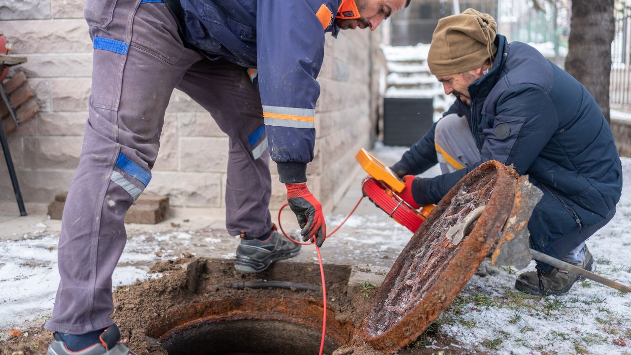
Utility locating identifies underground utilities before excavation using subsurface utility engineering (SUE). This process maps gas lines, power lines, water pipes, telephone cables, and fiber-optic cables through geophysical survey systems and advanced surveying. ASCE 38-22 defines four quality levels (QL-D through QL-A) for mapping underground infrastructure, with each level providing greater accuracy for construction utility mapping projects.
Private utilities represent 60% of subsurface infrastructure, making comprehensive utility mapping critical for infrastructure development and smart city construction.
Construction utility mapping uses risk-based quality levels defined by ASCE 38-22:
| Quality Level | Method | Accuracy | Use |
| QL-D | Desktop records, utility map review | Unverified | Planning |
| QL-C | Surface features + records | Inferred | Preliminary design |
| QL-B | Ground-penetrating radar, electromagnetic field detection | ±6-12" horizontal | Design-level mapping |
| QL-A | Vacuum excavation (potholing) | <±6" horizontal, <±2" vertical | Critical conflicts |
Ground-penetrating radar systems and electromagnetic locators handle QL-B work. QL-A provides the highest accuracy through physical exposure of subsurface utilities.
Modern utility locating equipment combines multiple technologies:
Utility strikes remain the construction industry's most preventable safety and financial risk. Between 400,000 and 800,000 incidents damage underground utilities annually across U.S. infrastructure development projects. These utility locating damage events disrupt pipeline infrastructure, compromise pipeline safety, and create cascading failures in natural gas delivery, power transmission, and telecommunications networks. The Common Ground Alliance's DIRT Report tracks these incidents, revealing that inadequate subsurface utility engineering drives escalating costs across municipal projects and private construction work.
Underground utility locating directly impacts regulatory requirements, safety standards, and cost control for facility managers overseeing infrastructure modernization initiatives.
Utility strikes cause severe human and operational harm. From 2000 to 2020, incidents involving gas lines, power lines, and other subsurface utilities resulted in 1,906 injuries and 400 fatalities across construction industry sites. Natural gas pipeline ruptures create explosion risks, while damaged electricity cables cause electrocutions.
Work stoppages average 8-12 weeks per utility locating damage incidents, halting infrastructure development projects and disrupting essential services. A 1998 Minnesota gas line strike killed four workers, injured twelve, and destroyed six buildings with $399,000 in direct damages. These consequences emphasize why underground utility locating has become critical for meeting safety standards and protecting pipeline infrastructure during construction utility mapping operations.
Direct repair costs range from $4,000 to $56,000 per strike, but the construction industry faces $62 billion in annual economic losses from utility locating damage. Research reveals a 29:1 ratio of indirect to direct costs—a $1 million repair actually costs $29 million when including project delays, idle equipment, regulatory fines, legal fees, insurance premiums, and reputational damage.
Cost control through subsurface utility engineering delivers measurable returns. Every dollar invested in utility mapping saves $4.62 in avoided utility strikes. Proper implementation of underground utility locating could eliminate $40 billion of annual losses, critical as $1.2 trillion in federal infrastructure modernization funding deploys across municipal projects, smart city construction, and pipeline infrastructure upgrades.
Responsibility for underground utility locating spans multiple stakeholders. OSHA enforces safety standards through 29 CFR 1926.651. PHMSA oversees pipeline safety for 3.3 million miles of pipeline infrastructure. Utility owners maintain records and respond to locate requests. Excavators initiate the One Call system. Facility managers coordinate subsurface utility engineering across infrastructure development projects.
The 811 One Call system delivers a 99% success rate, preventing utility strikes when used correctly. This public utility locate service processed 45.9 million 811 locate tickets in 2024, with 77% electronic submissions (91% in Canada). The system notifies utility owners who mark underground utilities—gas lines, power lines, water pipes, telephone cables, and fiber-optic cables—within 2-3 business days.
PHMSA mandates 811 notifications to protect pipeline infrastructure. The Common Ground Alliance's DIRT Report confirms that proper 811 locate ticket usage, combined with subsurface utility engineering, eliminates most preventable utility locating damage across construction industry projects.
Private utilities represent 60% of U.S. subsurface infrastructure, yet 811 excludes these underground utilities. Private utility lines include on-site power lines, water pipes, fiber-optic cables, and telephone cables serving individual facilities. This gap creates risk for municipal projects and smart city construction.
Notification failure causes 26% of utility strikes, mostly from excavators unaware that 811 doesn't cover private utilities. Professional underground utility locating using ground-penetrating radar systems, electromagnetic locators, and GPS-enabled mapping addresses this gap. Construction utility mapping for private utilities requires dedicated subsurface utility engineering beyond public utility locate protocols, driving utility locator market growth.
Voluntary adoption of subsurface utility engineering has plateaued despite decades of Common Ground Alliance advocacy. The DIRT Report shows utility strikes continue rising—the CGA Index increased to 96.7 in 2024 from 94.0 in 2023, reversing earlier progress. Nearly 197,000 utility locating damage incidents occurred in 2024, proving voluntary compliance insufficient for protecting pipeline infrastructure, gas lines, and subsurface utilities during infrastructure development projects.
The construction industry now shifts toward enforceable standards and regulatory requirements. Municipal projects increasingly mandate construction utility mapping through ASCE 38-22 protocols. State damage prevention laws impose stricter penalties while facility managers demand documented subsurface utility engineering for cost control and safety standards compliance. This trend toward mandatory underground utility locating reflects recognition that utility locating trends must evolve beyond voluntary best practices to systematic, enforceable frameworks governing infrastructure modernization and smart city construction initiatives.
Federal and state regulatory requirements mandate underground utility locating:
| Authority | Violation | Penalty | Notes |
| OSHA 2025 | Serious | $16,550 | Up from $16,131 |
| OSHA | Willful/Repeat | $165,514 | Up from $161,323 |
| OSHA | Failure-to-abate | $16,550/day | 30 days = $496,500 |
| States | Range | $125-$5,000 | Per violation |
| Pennsylvania | March 2024 | $357,525 | 376 actions total |
State damage prevention laws impose additional penalties for excavators, utility owners, and locators failing subsurface utility engineering requirements.
Subsurface utility engineering delivers $4.62 return per $1 spent (Purdue University). Prevention technology returns $0.33 per dollar after three avoided utility strikes.
The construction industry faces $62 billion annually in utility locating damage. Comprehensive underground utility locating using ground-penetrating radar systems and electromagnetic locators could eliminate $40 billion of losses. Critical as $1.2 trillion in federal infrastructure modernization funding is deployed across municipal projects, pipeline infrastructure upgrades, and smart city construction.
Advanced technologies transforming construction utility mapping:
The U.S. Utility Locator Market shows sustained expansion. Utility locating equipment sales: $912 million (2024) → $1.47 billion (2032), CAGR of 6.28%. Major manufacturers include Leica Geosystems AG, Radiodetection Ltd., Emerson Electric Co., The Charles Machine Works, Vermeer Corporation, 3M Company, and Subsite Electronics.
Professional underground utility locating services grow faster: $3.5 billion (2025) → $5.2 billion (2032). Services growth reflects construction industry demand for subsurface utility engineering across municipal projects and smart city construction. North America holds 35% market share; Asia Pacific grows fastest. Facility managers increasingly outsource construction utility mapping to specialists using ground-penetrating radar systems, hydrovac trucks, and 3D utility mapping for infrastructure modernization.
Subsurface utility engineering eliminates unexpected utility strikes that disrupt infrastructure development projects. The Common Ground Alliance's DIRT Report shows 38% of excavators face work delays due to incomplete underground utility locating, stalling construction industry schedules, and increasing costs. Comprehensive construction utility mapping using ground-penetrating radar systems and electromagnetic locators identifies conflicts before excavation begins, enabling design adjustments that avoid gas lines, power lines, water pipes, and fiber-optic cables.
Safety improvements prove measurable. Construction companies implementing rigorous utility locating protocols reduced excavation-related accidents by 30%. Preventing utility strikes protects workers from natural gas explosions, electrical hazards from electricity cables, and subsurface infrastructure collapses. Meeting OSHA safety standards through documented subsurface utility engineering reduces contractor claims, lowers insurance premiums, and builds stakeholder confidence. Facility managers overseeing municipal projects and pipeline infrastructure upgrades cite utility mapping as essential for regulatory requirements compliance and cost control across infrastructure modernization initiatives supporting smart city construction.
Subsurface utility engineering faces cost barriers, technical limitations, and data quality challenges. Utility locating equipment requires significant capital investment for ground-penetrating radar systems and electromagnetic locators. Accuracy depends on soil conditions and technology capabilities. Outdated utility maps create gaps in construction utility mapping even when excavators follow regulatory requirements.
These disadvantages impact small contractors on municipal projects where budgets constrain comprehensive underground utility locating services.
Utility locating equipment carries substantial expenses:
Small firms struggle to amortize utility locating equipment costs across intermittent construction industry work.
Technical constraints affect construction utility mapping:
Outdated utility maps are excavators' top challenge (Common Ground Alliance). Historical infrastructure development lacked systematic documentation—gas lines, power lines, telephone cables, and water pipes installed decades ago have incomplete records. Abandoned facilities complicate subsurface utility engineering. Operators must maintain records for utilities abandoned after 2002, but pre-2002 abandoned infrastructure lacks documentation.
Quality Level D records research proves unreliable when utility owners lack GIS data or digital mapping technology. Infrastructure modernization and smart city construction require updating legacy utility map databases with GPS-based mapping and GIS platforms, but comprehensive subsurface infrastructure data collection remains incomplete.
Professional underground utility locating requires certified technicians and proven utility locating equipment. Construction industry projects demand subsurface utility engineering specialists who meet regulatory requirements and use advanced ground-penetrating radar systems, electromagnetic locators, and GPS-based mapping for accurate construction utility mapping.
Essential qualifications for subsurface utilities detection:
Quality underground utility locating requires comprehensive utility locating equipment: ground-penetrating radar systems for non-metallic utilities, electromagnetic locators for power lines and gas lines, Cable Analyzers, and Time Domain Reflectometers for fiber-optic cables. Equipment must integrate with GIS platforms and GPS-enabled mapping for digital mapping technology compliance.
PAS 128:2022 standards ensure accurate subsurface infrastructure detection, supporting infrastructure development and municipal projects. Professional services from companies like Leica Geosystems AG, Radiodetection Ltd., and Vermeer Corporation provide construction utility mapping that meets safety standards for smart city construction and infrastructure modernization.
The future of utility locating integrates artificial intelligence, IoT sensors, and digital mapping technology. Utility locating trends shift toward AI-powered detection systems, real-time subsurface infrastructure monitoring, and mandatory subsurface utility engineering. The Common Ground Alliance's "50 in 5" challenge targets halving utility strikes by 2028, though 2024 shows continued growth requiring stronger regulatory requirements.
Artificial intelligence transforms underground utility locating through predictive analysis. AI-powered detection systems analyze ground-penetrating radar data and electromagnetic field patterns, predicting utility strikes before excavation. Real-time alerts notify operators approaching gas lines, power lines, water pipes, or fiber-optic cables. Automated interpretation accelerates subsurface utility engineering—artificial intelligence processes geophysical survey data faster than manual analysis. Major utilities like AT&T integrate AI workflows for predictive locates across pipeline infrastructure.
The DIRT Report tracks damage reduction progress:
Achieving targets requires expanded ground-penetrating radar systems deployment and comprehensive subsurface utilities protection.
Municipal mandates for subsurface utility engineering grow rapidly. Cities require construction utility mapping on municipal projects using ASCE 38-22 standards. Federal infrastructure development funding increasingly requires documented underground utility locating. State damage prevention laws impose enhanced penalties—OSHA 2025 fines reach $165,514 for willful violations.
Regulatory shift makes utility mapping standard for smart city construction, pipeline infrastructure, and infrastructure modernization. Facility managers face regulatory requirements demanding ground-penetrating radar systems, electromagnetic locators, and GIS platforms. The construction industry moves toward mandatory subsurface utility engineering as voluntary safety standards prove insufficient in preventing utility strikes.
Subsurface utility engineering has evolved from optional to an industry standard. The construction industry grew 10% in 2024, with infrastructure development spending exceeding $2 trillion. Systematic safety standards now replace voluntary compliance—municipal projects mandate construction utility mapping through ASCE 38-22, while regulatory requirements enforce underground utility locating across pipeline infrastructure and smart city construction.
Professional underground utility locating services grow 7.58% CAGR, outpacing utility locating equipment sales. Digital twins combining 3D BIM models with GIS platforms are now the default for urban infrastructure development, integrating ground-penetrating radar data, electromagnetic field detection, and GPS-based mapping. The Common Ground Alliance's Data Quality Index reached 71.7 in 2024, with top firms averaging 76. As utility locating trends accelerate toward AI-powered detection systems, Augmented Reality, and IoT sensors, comprehensive subsurface utilities protection becomes non-negotiable for infrastructure modernization, preventing the $62 billion annual cost of utility strikes affecting gas lines, power lines, fiber-optic cables, and subsurface infrastructure supporting smart city construction.
Prevent utility strikes costing $62 billion annually. Bess Utility Solution provides comprehensive subsurface utility engineering using ground-penetrating radar systems, electromagnetic locators, and GPS-based mapping. Our NULCA-certified technicians deliver ASCE 38-22 construction utility mapping for gas lines, power lines, water pipes, and fiber-optic cables across infrastructure development projects.
Protect your project. Contact Bess Utility Solution for underground utility locating, meeting regulatory requirements, and preventing utility locating damage.