Hayward, CA
Fresno, CA
Orange, CA
Sacramento, CA
Phoenix, AZ
Key Takeaways:
Winter construction demands precision when margins for error disappear. Frozen ground, shortened daylight, and compressed schedules create conditions where assumptions become catastrophes. The U.S. experiences 400,000 to 800,000 utility strikes annually, costing $30 billion. Each strike averages $4,000 in direct damages, but indirect costs multiply that by 29 times.
The 2024 CGA DIRT Report analyzed 196,977 damage incidents. The CGA Index rose from 94.0 to 96.7. The construction sector isn't meeting its "50-in-5" goal. When utility locating gets skipped or rushed, consequences multiply. Making professional utility locating the first step isn't optional—it's the foundation every winter project must build on.
Winter transforms standard excavation into high-risk operations. Ground conditions degrade detection accuracy. Human performance suffers. Schedule pressure forces dangerous shortcuts.
Frozen soil becomes compacted and brittle, requiring greater excavation force that increases accidental utility damage likelihood. Utilities can shatter on impact in cold temperatures. Freeze-thaw cycles saturate soil, creating unpredictable conditions and trench collapse risk. When soil moisture freezes, resulting ice has much higher dielectric constant than unfrozen soil, increasing signal attenuation in detection equipment. Radar waves lose energy quickly through frozen ground, diminishing penetration depth and detection accuracy significantly.
Snow and ice create specific GPR challenges. Ground-coupled antennas work best close to the ground surface. Snow effectively lifts antennas off ground, reducing energy transmission and penetration depth. Ringing effects occur when snow or ice reaches a certain thickness—multiple reflections from ground surface severely impact visibility of target utilities. Typical hyperbola reflections from underground storage tanks may only be partially visible. Frozen surfaces create stronger reflections causing clutter, making it difficult to distinguish actual utilities from background noise. Real-time interpretation becomes difficult precisely when operators need it most.
Shorter daylight compresses work windows. Reduced visibility makes it difficult to see ground markings and spot hazards. Winter weather—snow, sleet, fog—further degrades visibility. Cold reduces worker dexterity and focus, increasing error risk. When hands are numb and attention divides between work and staying warm, precision suffers. These conditions transform routine operations into error-prone activities where even experienced crews make mistakes that wouldn't occur in better conditions.
Immense pressure exists to complete projects before calendar year end for budgetary and contractual reasons. This "year-end rush" leads to accelerated schedules and safety protocol disregard. The temptation to skip or rush utility locating to save days contributes significantly to increased strike frequency. The CGA DIRT Report shows 38% of excavators can't start work on time due to incomplete location responses. Late locates combined with year-end pressure create conditions where critical safety steps get skipped. Risk per project elevates in winter despite lower overall construction volume.
Utility locating identifies and maps underground infrastructure before any excavation begins. This process uses electromagnetic detection, ground-penetrating radar, and physical verification to create accurate subsurface pictures that guide safe excavation decisions.
Electric utilities carry deadly voltage. Gas lines pose explosion and asphyxiation risks. Communications and fiber optic cables connect critical infrastructure. Water mains flood sites. Sewer lines create health hazards. Oil and chemical lines demand immediate hazmat response. The 811 color code standardizes identification: red for electric, yellow for gas, orange for communications, blue for water, green for sewer. Water, sewer, telecommunications, and CATV utilities dominated nine of the top ten root causes in the CGA DIRT Report. Utility work itself drives the majority of damages, making comprehensive identification critical before any ground disturbance.
Incorrect facility records and maps cause 2.16% of utility damages. Underground infrastructure changes constantly without documentation updates. Utilities get added, rerouted, or abandoned without updates. A five-year-old map may miss three subsequent projects. The national 811 service covers public utilities but often excludes privately owned infrastructure. Private utilities on industrial sites, university campuses, or hospital complexes don't appear in standard locate responses, requiring specialized private locating services for complete subsurface intelligence.
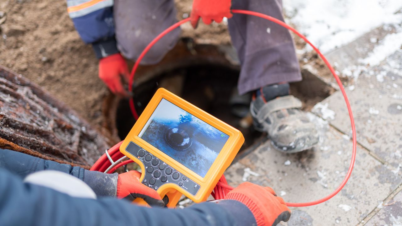
Layered verification combines multiple detection methods: pre-excavation utility locating through 811 calls and private locators, GPR surveys, electromagnetic detection, vacuum excavation potholing, real-time detection technology, and comprehensive site mapping. Ground-penetrating radar excels at non-metallic utilities. Electromagnetic cable locators trace metallic lines. Both require proper cold-condition calibration. Multiple detection methods provide comprehensive subsurface intelligence. Each layer catches what previous methods miss, reducing cumulative error rates and eliminating dangerous assumptions about what lies below.
Making utility locating the first step prevents the cascading failures that devastate winter projects. Early subsurface intelligence eliminates surprises that stop work and multiply costs.
The U.S. experiences 400,000 to 800,000 utility strikes annually, costing $30 billion in excavation-related damages. Each strike averages $4,000 in direct damages, but for every dollar in direct damage, indirect costs add $29 more. The 2024 CGA DIRT Report documented 196,977 unique damage incidents. Strikes trigger immediate emergency protocols. Struck utilities must be isolated, often requiring neighborhood or district-wide shutdowns. Emergency crews respond, excavation stops, investigations begin.
Repair costs vary dramatically by utility type. Water mains require excavation, pipe replacement, and resealing. Electrical cables demand splicing, new insulation, and comprehensive safety checks. Oil and gas lines need leak detection, pipe replacement, and mandatory regulatory compliance inspections. Fiber optic cable repairs require specialized skills, splicing equipment, and extensive materials and testing—often the costliest repair category. Understanding why utility locating is essential helps teams appreciate how first-step verification prevents these cascading costs.
Improved strike prevention could save $40 billion in infrastructure project costs. When strikes occur, construction teams and equipment idle until issues resolve. Extended labor costs mount from idle personnel. Equipment rental periods extend beyond budget. New paperwork and permits stretch timelines. Disrupted project cash flow creates financial pressure across all stakeholders. Redesigns become necessary when struck utilities can't be relocated as planned. Engineering costs multiply. Material orders change. Subcontractor schedules collapse. Early utility data eliminates these surprises, allowing projects to proceed confidently even when winter conditions already challenge progress.
States with active enforcement programs achieved significantly higher on-time rates for locating responses. Early utility locating scheduled weeks before excavation eliminates delays from critical paths. Weather delays become manageable when utility data already exists. Crews use weather downtime to review subsurface information rather than waiting for locating services. Real-time detection technology minimizes striking risks in frozen ground. Crews don't wait for ground thawing when they know exactly where utilities run. This intelligence allows superintendents to sequence work around verified utility locations, scheduling sensitive excavation when conditions are optimal and experienced crews are available.
Risk concentrates unevenly across project stakeholders. Contractors face immediate liability. Public agencies carry political consequences. Facility owners inherit long-term impacts.
Failure to notify 811 causes 24.54% of all damages—the single largest root cause. Excavators failing to maintain clearance after verifying marks cause 16.07%. Improper excavation practices account for 6.75%. Digging before potholing verification causes 4.94%. Failure to shore excavations adds 3.27%. These statistics represent contractor decisions and on-site choices, not locator errors or utility company failures. Contractors carry full liability, facing penalties, litigation, and insurance consequences extending years beyond initial strikes. The financial and reputational damage persists long after physical repairs complete.
Public projects affect broader populations than private work. Municipal service disruptions impact traffic management, emergency response, and sewage treatment. Cities must repair or compensate for interrupted services at premium emergency rates. Legal actions can target public agencies for inadequate project oversight or contractor selection. Media coverage amplifies incidents. Elected officials demand explanations. Consequences extend beyond financial costs into political and reputational damage affecting future funding and project approvals. Public project strikes become political liabilities that affect careers and agency budgets for years.
Facility owners lose client trust when strikes cause service disruptions. Potential clients hesitate to engage with organizations having recent strike histories. Negative word-of-mouth spreads through industry networks, affecting relationships with clients, partners, and investors for years. Frequent utility damage claims raise insurance premiums across all coverage types. Insurers consider risk profiles based on claim frequency and severity. Strike history drives up coverage costs and may prevent contractors from obtaining insurance altogether, effectively ending market participation. The reputational damage persists long after physical infrastructure gets repaired.
Understanding root causes enables targeted prevention. Record inaccuracy, high-density corridors, and jobsite control breakdown drive most winter strikes.
Facilities not marked due to locator error account for 11.94% of damages. Inaccurate marking from locator error causes 8.58%. No response from operators or contract locators leaves facilities unmarked in 4.71% of cases. Even professional locating has error rates. These statistics underscore why multiple verification methods become essential. When GPR, electromagnetic detection, and physical potholing all confirm the same subsurface picture, confidence increases dramatically. Single-method reliance creates dangerous gaps that winter conditions exploit.
Hiring private utility locating services becomes essential for complete subsurface pictures. Large facilities, campuses, and industrial sites contain extensive private utility networks invisible to standard locate services. High-density corridors where multiple utilities run in proximity amplify strike risk exponentially. One excavation error can damage multiple lines simultaneously, compounding consequences. Winter conditions make these complex subsurface environments even more dangerous when detection accuracy degrades and human performance suffers from cold exposure.
Snow and ice obscure utility markings critical for identifying safe excavation zones. Standard utility markings—paint and flags—become useless in winter weather. Snowfall completely covers markings. Ice and moisture cause paint to fade or wash away. The CGA DIRT Report confirms marks faded, lost, or not maintained cause 2.17% of all damages. Snow and winter conditions exponentially exacerbate this problem. Sites marked a week prior may be completely unmarked after snowstorms, creating false security that leads to strikes. Standard paint markings simply cannot withstand winter conditions without constant reapplication.
Professional locating adapts detection methods and verification protocols to compensate for winter's challenges. Technology selection and deployment strategies change based on ground temperature, moisture content, and snow cover.
GPR works well through snow or ice—signals aren't blocked—but faces limitations. In GPR-friendly soils like dry sands, thin snow or ice cover generally isn't serious. Ground-penetrating radar and electromagnetic cable locators must be properly calibrated for cold conditions. They provide reliable means of locating underground utilities in challenging weather when operators understand winter limitations and adjust accordingly.
Electromagnetic locating requires special winter adaptations. Frozen ground affects conductivity. Snow and ice interfere with signal transmission. Equipment must be recalibrated for cold conditions. Multi-frequency approaches work better in frozen ground. Specialized techniques address permafrost and frozen soil. Regular equipment calibration in cold weather maintains accuracy. These adaptations make EM locating viable year-round when properly implemented by experienced operators.
Data processing techniques can reduce ringing effects but aren't practical for real-time interpretation. When winter conditions degrade individual method performance, multiple verification methods become essential. The top ten root causes account for 85% of all utility damages. When GPR, electromagnetic detection, and physical potholing all confirm the same subsurface picture, confidence increases dramatically. No single technology suffices in winter—comprehensive approaches combining multiple detection methods provide the only reliable subsurface intelligence.
Use high-visibility, weather-resistant paint with frequent reapplication due to snow cover. Deploy elevated markers or stakes extending above the snow line. Maintain GPS documentation as backup to physical markings. Implement digital mapping to supplement physical marks. Clear snow thoroughly before each work period. Reapply utility markers with weather-resistant paint as needed. Use advanced detection technologies when conditions warrant additional verification. Daily safety briefings should reference specific utility locations relative to that day's excavation zone, ensuring constant reinforcement prevents complacency.
Vacuum excavation and potholing provides non-destructive verification when winter conditions degrade other detection methods. Physical confirmation eliminates dangerous assumptions about subsurface conditions.
Modern vacuum excavators operate with integrated water heaters designed for temperatures as low as -40°F, making this the safest winter digging method. Integrated vacuum excavation tools identify underground cables before full excavation begins. Equipment uses pressurized water or air to loosen soil and vacuum systems to remove it. Utilities remain untouched while excavation proceeds to required depths. This represents the most reliable way to verify exact horizontal and vertical utility location, safely exposing infrastructure without mechanical excavator bucket damage risk.
Winter maintenance keeps systems operational: check airline hoses for cold-induced cracking, ensure air dryers function to prevent moisture freezing, inspect lights for burnout and accumulated snow, conduct regular oil changes and battery inspections, monitor hydraulic fluid and hose condition, drain water systems completely after each use, maintain regular equipment checks and recalibration. These steps ensure reliable performance through temperature extremes.
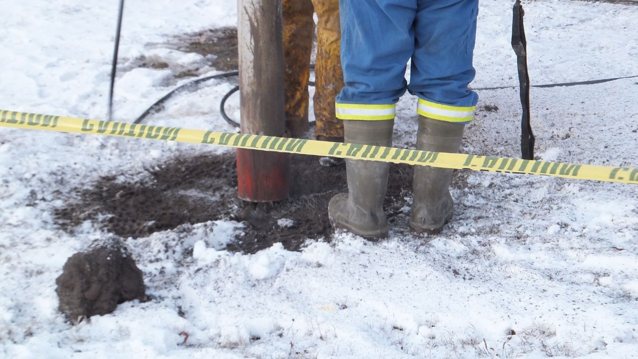
Use ground-thawing equipment like hydronic heaters to soften soil before excavation. Near marked cables, use manual excavation with insulated tools that minimize force application. Physical verification through potholing is essential before full-scale excavation. This represents a critical step for verifying location of critical utilities in the immediate vicinity of planned excavation. The process should be used before starting work on any project, but becomes absolutely mandatory in winter when other detection methods face degraded accuracy.
Verified subsurface data prevents rework that devastates winter schedules. Rework in winter costs more than summer rework. Frozen ground, shortened work days, and weather interruptions make every hour of lost productivity more expensive. The additional time required for potholing pays for itself many times over by avoiding strike-related costs, delays, and safety incidents. When winter weather can change conditions hour by hour, physical verification provides the only certainty that excavation can proceed safely.
GPR concrete scanning faces fewer winter limitations than soil scanning. Concrete's consistent properties enable reliable winter detection of embedded elements that would be invisible to other methods.
Post-tension cables, rebar, and conduits within concrete slabs show clearly on GPR scans regardless of surface temperature. Concrete's consistent density and moisture content remain relatively stable through temperature changes. GPR signals pass through snow and ice without blocking. Concrete scanning maintains reliability when ground scanning would be problematic, making winter optimal for concrete infrastructure work requiring subsurface verification before cutting, coring, or anchoring operations begin.
Winter is an acceptable time for concrete scanning when ground scanning faces maximum difficulty. Damage to post-tension cables can cause catastrophic structural failure. GPR must be properly calibrated for cold conditions to deliver accurate results. The cost of pre-work scanning pales against potential structural damage and safety consequences. December's accelerated schedules make this verification even more critical when crews lack time to recover from mistakes that could have been prevented with proper scanning.
Mark findings with elevated stakes extending above expected snow depths. Use GPS documentation to supplement physical markings. Digital records prevent loss of critical information when snow covers sites. Field crews need clear communication about detection limitations. Multiple documentation methods ensure winter conditions can't eliminate all excavation guidance. Daily briefings should reference GPR findings relative to that day's work, ensuring every crew member understands what lies below their work area before equipment starts.
Accurate mapping and digital models maintain subsurface intelligence when physical site conditions degrade visibility and accessibility. Preventing costly mistakes during site preparation starts with comprehensive subsurface documentation.
GPS-based digital mapping creates permanent, weather-independent records of utility locations. Site mapping must include high-visibility, weather-resistant markings supplemented by digital coordinates. Maps must show utility types, depths, routing, and confidence levels. Uncertainty should be clearly indicated, not hidden. Maps guide daily work when site conditions prevent direct observation of physical markings. This information becomes critical when snow obscures sites and verbal communication suffers in cold, windy conditions.
Multiple documentation methods ensure winter conditions can't eliminate all excavation guidance. Data integration allows real-time decision-making. Crews verify position relative to known utilities even when visual markers are invisible under snow. 3D models provide spatial understanding that 2D plans can't match. Different trades access the same model, ensuring consistent understanding. Coordination improves. Conflicts get identified before equipment mobilizes. The visual clarity of 3D models transcends language barriers and experience levels, ensuring even temporary workers understand subsurface conditions.
When crews know precisely where utilities run, excavation proceeds confidently. No surprises mean no emergency stops. Projects maintain momentum even when winter weather already challenges schedules. Accurate mapping prevents cascading delays from idle personnel and extended equipment rentals. The time invested in comprehensive mapping delivers returns throughout the project lifecycle, particularly during compressed winter schedules when every day counts toward completion deadlines.
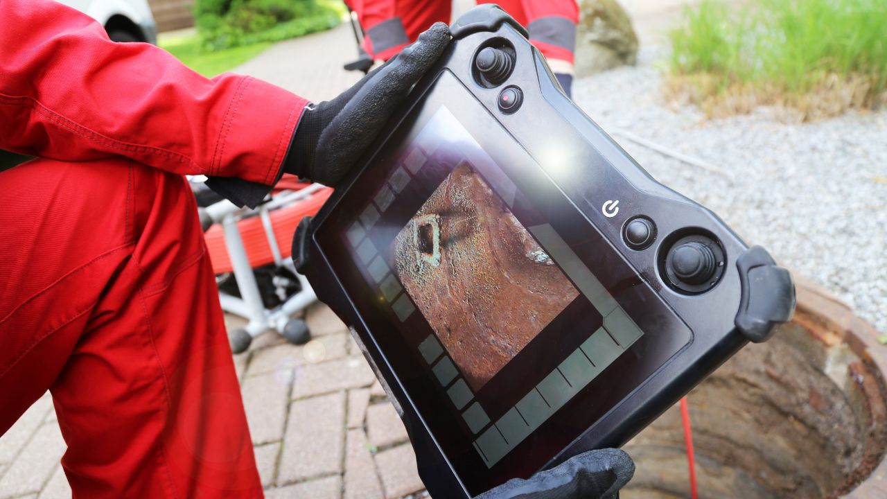
CCTV inspection reveals pipeline conditions without excavation. This information guides decisions about excavation timing, methods, and safety protocols when winter conditions make exploratory excavation particularly challenging.
Water main bursts require extensive flooding cleanup. Gas leaks and oil or chemical spills demand immediate containment and cleanup. Specialized equipment like vacuum trucks for spills adds thousands per hour to response costs. Environmental regulations require proper disposal of contaminated materials at premium prices. Remediation must prevent harm to soil, groundwater, and ecosystems. Testing and confirmation of cleanup results extends timelines significantly. CCTV inspections reveal pipe conditions, joint integrity, blockages, and structural weaknesses, allowing teams to plan excavations around vulnerable sections or schedule repairs proactively rather than responding to emergency failures.
Sewage spills contaminate soil, groundwater, and surface water, disrupting ecological balance. Oil and chemical spillages prove impossible to fully extract once seeped into soil—complete soil removal becomes necessary. CCTV inspection becomes preferable when pipeline condition uncertainty exists but excavation timing is flexible. When winter excavation can be avoided by confirming pipeline integrity through inspection, the safer choice is inspection. Visual confirmation of pipe condition eliminates guesswork about whether immediate excavation is necessary or can be deferred to better weather.
Utility strikes trigger immediate consequences that expand into long-term impacts across safety, financial, and legal domains. Winter amplifies all consequences.
The greatest risk remains individual safety: electrical shocks, gas leaks, hazardous material exposure causing immediate injuries or long-term health issues. Strikes create financial, ethical, legal consequences and devastate team morale. Cold weather compounds response challenges. Reduced worker dexterity slows emergency reactions. Winter conditions complicate hazmat containment. Heavier, colder air keeps gas concentrations at ground level longer. Buildings with closed windows and active heating systems accumulate dangerous levels quickly, turning routine gas leaks into evacuation emergencies.
Environmental impacts create lasting costs. Water contamination from flooding and pollutant release requires extensive remediation. Gas leaks cause air pollution and methane emissions affecting air quality and climate change. Increased emissions from road closures, traffic rerouting, and idling vehicles add environmental costs that persist long after repairs complete. Winter makes all cleanup operations more difficult and expensive.
Legal actions from affected parties include attorney fees, court proceedings, and settlements. Damage to neighboring properties, businesses, and public infrastructure triggers multiple claims. Municipal services affected—traffic management, emergency response, sewage treatment—require repair or compensation. Multiple penalty mechanisms activate simultaneously. Contractual Service Level Agreement violations result in financial penalties. Milestone slips cascade into additional penalties. Clients, local authorities, utility companies, and municipal authorities all impose their own penalty structures.
Damage to excavation equipment requires repair or replacement. Delays during repairs or equipment replacement extend project timelines. Urgent repair costs exceed planned maintenance significantly. Safety standard violations compound penalties. HSE HSG47 establishes best practices for identifying and managing underground utility risks. PAS 128 provides frameworks for underground utility surveys. Comprehensive risk assessments are legally required. Violations during incident investigations lead to additional penalties and potential criminal liability for safety officers and company principals.
Insurance claims require extensive paperwork, documentation, and communication trails. Regulatory compliance demands incident reporting to multiple authorities. Legal representation uses documentation to defend against or prosecute claims. Administrative and legal costs often exceed direct repair costs but receive less attention during project planning. Records of 811 calls, private locating reports, GPR surveys, potholing verification, and pre-excavation safety meetings demonstrate reasonable care. When strikes occur despite proper procedures, documentation limits liability. Without documentation, even contractors who followed proper procedures face difficulty proving compliance.
Winter scheduling requires different approaches than summer projects. Advanced planning and verified subsurface intelligence make winter construction both feasible and safe without compromising either schedule or safety.
Schedule utility locating at least two weeks before planned excavation start dates. This buffer accommodates weather delays, incomplete utility records requiring additional research, and follow-up verification when initial results show conflicts. Winter weather can delay locating crews just as it delays excavation crews. Building schedule cushion prevents pressure to proceed without complete utility data. The investment in early planning pays dividends when winter schedules compress and teams face pressure to start immediately.
Projects experience minimal delays when excavation proceeds with confidence rather than hesitation. The CGA Index rose from 94.0 to 96.7, showing the industry moving backward. The construction sector isn't on track to meet the 50-in-5 goal. Damages track with construction activity, not improvements. This data reveals that most projects still operate reactively rather than proactively.
Live Dig Radar technology embeds directly into excavator buckets, eliminating the distance signals must travel through frozen ground. The system generates new scans in real-time with each dig. "Next-digging-bite" detection sees what's inches ahead. Real-time alerts deliver directly to operators in warm cabins. This technology minimizes risk of striking shallow utilities in frozen ground, reduces downtime, increases safety in icy conditions, and produces minimal project delays. When combined with comprehensive pre-excavation utility locating, real-time detection creates layered protection that keeps winter projects moving safely.
Making utility locating the first step requires systematic commitment, not just good intentions. Specific actions embed this priority into project workflows.
Pre-excavation safety meetings should review winter-specific hazards before equipment arrives on site. Confirm all locating methods completed and documented. Verify equipment calibration for cold weather operation. Establish clear communication protocols for winter conditions when normal methods may fail. Review emergency response procedures specific to winter hazards like gas leaks in snow-covered areas or electrical faults near ice. Schedule utility locating at least two weeks before planned excavation start dates to accommodate inevitable winter delays.
Verify providers use GPR properly calibrated for cold conditions. Confirm they deploy electromagnetic cable locators with winter-appropriate settings. Ask about advanced detection technologies and winter-specific capabilities. Check experience with frozen ground and winter excavation support. Verify availability of vacuum excavation services rated to -40°F. Request GPS documentation and digital mapping as standard deliverables. Ask about winter-specific marking protocols: How often will they reapply marks during snow events? Do they use elevated stakes extending above expected snow depths? What weather-resistant paint formulations do they employ? These questions reveal whether providers understand winter challenges or simply apply summer methods year-round.
Daily safety briefings should reference specific utility locations relative to that day's excavation zone. Crew members need to understand not just that utilities exist, but where they run relative to current excavation activities. Constant reinforcement prevents complacency. Site mapping must include high-visibility, weather-resistant markings that crews can reference throughout work periods. When weather obscures physical marks, digital records and GPS coordinates guide excavation decisions. Contact experienced professionals to establish protocols that maintain subsurface awareness throughout winter projects.
Winter construction without comprehensive subsurface verification is indefensible. Prevention requires systematic approaches that treat utility locating as the foundation, not an afterthought.
CGA recommendations focus on reducing damages from failure to contact 811 through improved enforcement, targeting high-risk sectors like water, sewer, and telecommunications with specialized contractor training, implementing balanced enforcement affecting all stakeholders, scaling proven practices from successful organizations, and accelerating data-driven decision-making. These recommendations recognize that preventing utility strikes requires industry-wide commitment. Prevention starts with acknowledging that subsurface conditions must be verified, not assumed. Every excavation begins with the question: what lies below? Answer that question definitively through professional utility locating before equipment breaks ground.
Required PPE includes thermal high-visibility clothing, insulated gloves maintaining grip and flexibility, and anti-slip boots. Grit for icy areas around excavation sites prevents slips and falls. Wearable temperature monitors ensure workers remain within safe exposure limits. Low temperatures compromise mechanical performance across all equipment types. Hydraulic systems and batteries operate less efficiently in cold, requiring winter-specific lubricants and frequent recalibration. Equipment requires frequent checks. Detection devices must be recalibrated to account for environmental effects. These measures protect workers but don't eliminate utility strike risks. Comprehensive subsurface planning protects both personnel and infrastructure by confirming conditions before committed excavation begins.
Comprehensive approaches require technical preparation, worker safety measures, regulatory compliance, advanced detection technology, and equipment maintenance and calibration. Each element supports the others. Technical preparation without proper equipment maintenance fails. Worker safety measures without accurate utility data create false confidence. Regulatory compliance without genuine understanding becomes box-checking that misses real hazards. Infrastructure protection delivers the clearest return on investment. Neighboring properties, businesses, and public infrastructure remain undamaged. Service continuity continues without interruption. Reputations stay intact. Projects complete on schedule and budget.
The industry recognizes this reality: "Frozen ground, poor visibility, and adverse weather not only make operations more difficult but also amplify the potential for accidents." Winter construction demands higher standards, not relaxed ones. The margin for error shrinks to zero when weather, schedules, and ground conditions all work against safe excavation. Only systematic attention to subsurface conditions before excavation begins protects projects from cascading failures that turn winter construction into winter catastrophes.
Winter construction succeeds when utility locating becomes the foundation, not an afterthought. Bess Utility Solutions combines advanced detection technology with comprehensive winter excavation experience to provide the subsurface intelligence that keeps projects safe, compliant, and on schedule through the harshest conditions.
Don't let frozen ground, shortened daylight, or schedule pressure force dangerous assumptions about what lies below. Contact Bess Utility Solutions today for professional utility locating, vacuum excavation, GPR scanning, and comprehensive subsurface verification services designed specifically for winter construction challenges. Your project's success starts with knowing what's underground before any excavation begins.