Hayward, CA
Fresno, CA
Orange, CA
Sacramento, CA
Phoenix, AZ
Key Takeaways
In Arizona, utility location can be a daunting task due to the complex soil conditions and unique landscape. Underground utility systems, including gas, electric, water, and sewer lines, often lie hidden beneath the surface, making accurate identification and marking a critical part of any excavation project. Whether you’re working on a construction site or simply need to locate utilities for property management, using the right utility locating methods ensures safety and efficiency.
At Bess Utility Solutions, we understand how challenging it can be to identify and mark these utilities, especially in Arizona’s desert environment. With our expertise in private underground utility locating services, we leverage advanced technologies to provide precise and reliable utility locating services. In this article, we explore the challenges of locating utilities in Arizona’s diverse soil conditions and discuss the methods that improve accuracy.
Arizona’s desert terrain is known for its rugged landscape, which presents several challenges when it comes to locating underground utilities. The soil here varies significantly across regions, often characterized by compacted ground, rocky substrates, and areas with little to no moisture. These soil conditions can affect the performance of utility locating equipment, making the process more difficult.
For instance, ground penetrating radar (GPR), a common tool for utility detection, relies heavily on the soil’s moisture content to transmit signals. In dry, sandy soil, GPR can struggle to get a clear reading, while in more densely compacted soils, signal penetration might be limited. This variability makes it even more important to select the right utility locator and method to suit the terrain.
Vacuum excavation or potholing is one method that helps mitigate these challenges. By using high-pressure air or water to safely expose utilities, this technique allows for a more accurate and precise understanding of utility depth and location without causing damage. As a part of subsurface utility engineering, this method ensures a clearer view of the underground infrastructure, helping locate buried pipes, cables, and other critical infrastructure components more reliably
.
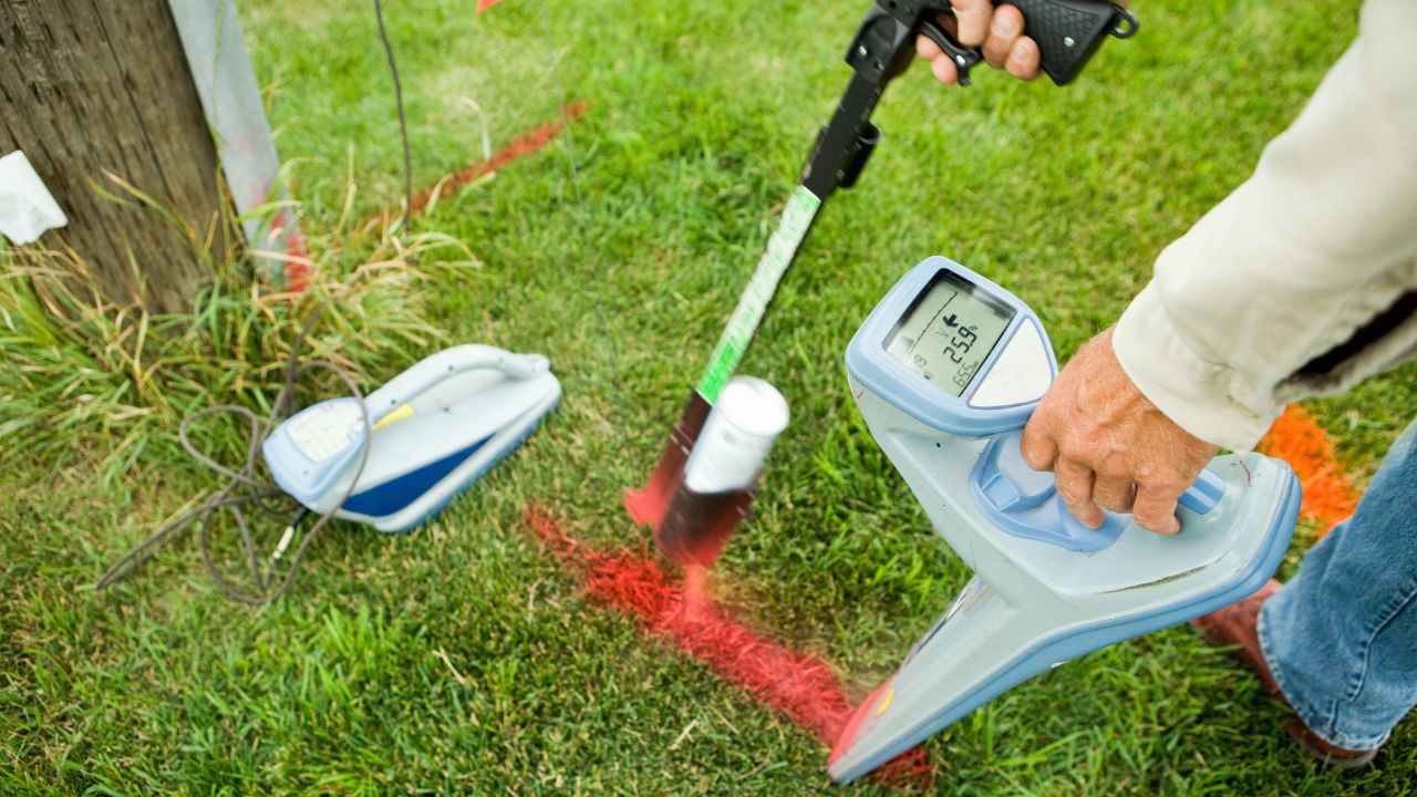
One of the most reliable methods for locating utilities is the use of ground penetrating radar (GPR). GPR is particularly effective in detecting metallic and non-metallic utilities such as sewer lines, natural gas pipelines, and utility service lines. By sending radar waves into the ground and analyzing the reflected signals, GPR can provide real-time data on the location and depth of underground utilities.
However, in Arizona’s dry, sandy soil, GPR's effectiveness can diminish. This is where combining GPR with other methods, such as electromagnetic (EM) locating equipment, becomes essential. EM locators are useful for tracing utility lines that have tracer wires, making them easier to detect in challenging soil conditions.
Electromagnetic detection is another technology frequently used in private utility locating services. This method works by emitting a signal along the utility line, which is then picked up by a receiver. It is particularly useful for public utilities such as electrical and water lines, as well as private utilities like irrigation systems.
Electromagnetic locators are less sensitive to soil type than GPR, which makes them ideal for Arizona’s diverse landscape. Whether the soil is loose, compacted, or rocky, an EM locator can effectively trace the path of utility lines, making it a critical tool for accurate utility mapping.
When precise utility detection is crucial, vacuum excavation and potholing are invaluable methods. This technique uses a powerful vacuum system to safely expose buried utilities without causing damage. By digging carefully and methodically, vacuum excavation ensures that workers can identify utilities at various depths, whether they are under parking lot lighting or electric service lines.
The vacuum excavation process allows for a clear understanding of the utility depth and can pinpoint the location of utility pipes, underground storage tanks, and other subsurface infrastructure. This method helps mitigate the risks of damaging underground utilities during excavation, which is particularly important in areas with critical infrastructure like sewer lines or natural gas pipes.
To ensure that you have an accurate understanding of the utility network, utility mapping services are essential. Advanced utility mapping involves creating detailed drawings of underground utilities, including CAD & GIS drawings, which offer a precise visual representation of the utility layout. These maps provide a comprehensive overview of the subsurface network, helping to prevent accidents and ensuring regulatory compliance.
By using cutting-edge geospatial technology and combining it with subsurface utility engineering, we can create accurate maps that show the location of buried pipes, tracer wires, and other utilities. These maps help contractors, property owners, and utility companies understand the underground infrastructure, reducing the risk of utility strikes during construction projects.
When dealing with underground utility services, identifying different types of utilities can present additional difficulties. Not all utilities are easily detectable by the same methods, and some may be more difficult to locate than others.
For example, electric service lines may be easily identified using electromagnetic detection, while water lines might require more specific methods like GPR or even visual inspection if accessible points are available. Private utilities such as irrigation systems and fire control systems may not always be traced using standard methods, requiring specialized approaches like vacuum excavation potholing.
Additionally, public utility infrastructure, such as sewer lines or utility service lines, must be located with extreme care to avoid costly damage. Coordination with local utility companies and public utility locating services is critical in ensuring a safe excavation process. Properly marking and identifying these utilities is not only a matter of efficiency but also safety, ensuring that the worksite remains free from hazards like utility strikes or service interruptions.
Utility location in Arizona’s complex soil conditions demands precision and expertise. Whether you are dealing with challenging desert landscapes or need to ensure the safe and accurate identification of underground utilities, Bess Utility Solutions has the tools and experience to handle the job. From vacuum excavation to advanced ground penetrating radar technology, we offer a range of solutions that provide clear, accurate results.
For those seeking underground utility locating services in Phoenix and surrounding cities in Arizona, Bess Utility Solutions provides cutting-edge RFID marking and locating solutions that can transform your utility management strategy. Contact BESS today and take the next step toward more efficient and accurate underground utility management.


