Hayward, CA
Fresno, CA
Orange, CA
Sacramento, CA
Phoenix, AZ
Key Takeaways
Utility locating services identify underground utilities before construction to prevent utility strikes and construction project delays. Professional locating companies use Ground Penetrating Radar, electromagnetic locating equipment, and vacuum excavation to find subsurface utilities, including water, sewer mains, natural gas, fiber optics, and electrical lines.
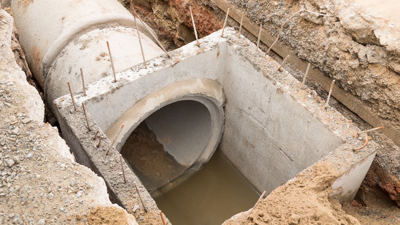
The ASCE 38-22 standard defines four Quality Levels: QL-D (records review), QL-C (surface survey), QL-B (geophysical designation using electromagnetic locating and ground-penetrating radar), and QL-A (precise 3D utility location via vacuum excavation test holes). Licensed engineers certify utility location data, supporting damage prevention and change orders prevention through accurate underground infrastructure mapping.
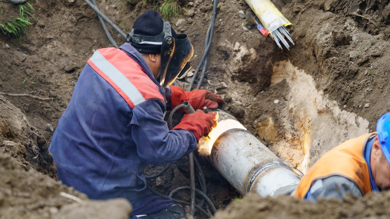
Utility locating services are critical for damage prevention and public safety. According to the Common Ground Alliance DIRT 2023 report, 76% of utility damages stem from six root causes, with failure to call before you dig 811 being the leading cause. Each utility strike threatens critical infrastructure, causes construction project delays, triggers change orders, and risks worker safety when hitting natural gas lines, fiber optics, or electrical cables.
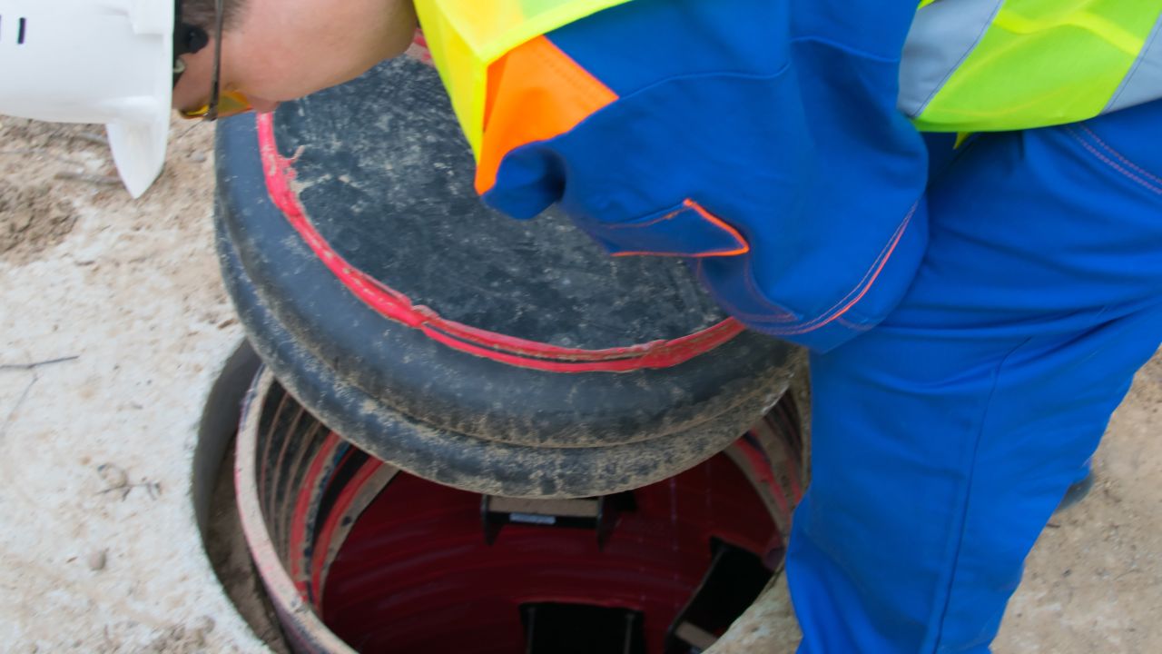
Public utility locating services through 811 services cover only utilities up to the meter, but 60-65% of underground utilities are private, including site lighting, irrigation, and private onsite utilities beyond the service connection. Comprehensive utility protection requires both 811 process compliance and private utility locating to map the complete underground infrastructure network. Without both public and private locating service coverage, contractors face unexpected utility strikes that halt construction and generate costly change orders.
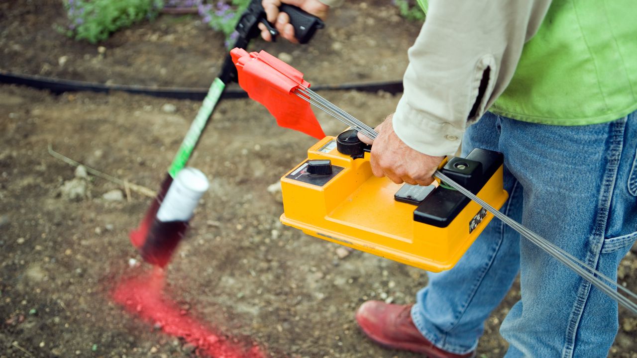
Underground utility locating services employ multiple advanced technology methods to detect subsurface utilities. Professional locating companies select the appropriate technique based on utility type, soil conditions, and project requirements. Ground Penetrating Radar, electromagnetic locating equipment, and acoustic methods each provide specific advantages for mapping underground infrastructure and utility lines.
The three primary utility location technologies work together for comprehensive detection. Ground Penetrating Radar penetrates subsurface materials to identify all utility types, including non-metallic pipes. Electromagnetic locating uses electromagnetic induction to trace metallic utility lines and cables. Acoustic leak detection identifies pressurized water and natural gas systems. Combining these methods ensures accurate utility mapping across different underground utilities and site conditions.
| Technology | Detects | Limitations |
| GPR | All materials | Clay/water interference |
| EM | Metallic only | Can't detect plastic |
| Acoustic | Pressurized lines | Limited to water/gas |
Understanding the difference between 811 services and private utility locating is essential for comprehensive damage prevention. Public utility locating services through Call before you dig 811 are free and legally required, but cover only public utilities up to the meter or service connection. Private locating service providers map the remaining 60-65% of underground utilities, including private onsite utilities, site infrastructure, and utility lines beyond the meter.
Private utility locating offers certified accuracy that 811 services cannot provide. While 811 marks horizontal utility location with no depth information or engineering certification, private locating companies deliver precise subsurface utilities data using Real-Time Kinematic Positioning, CAD drawings, and infrastructure mapping. Professional locate services achieve 99.8% accuracy with QL-A vacuum excavation, providing ±1 inch precision in three dimensions—critical data for preventing construction project delays and change orders on complex sites with dense underground infrastructure.
| Feature | 811 | Private |
| Coverage | Public to meter | Private beyond the meter |
| Cost | Free | $5K-$30K |
| Depth | No | Yes (±1 inch QL-A) |
| Accuracy | Not certified | 99.8% certified |
Utility locating services eliminate construction project delays by identifying underground utilities before excavation begins. Accurate utility location data integrated into 3D BIM models enables clash detection during design, revealing conflicts between proposed construction and existing subsurface utilities before crews mobilize. This proactive approach using infrastructure mapping and advanced technology prevents the costly work stoppages that occur when contractors encounter unmarked utility lines during excavation.
Precise utility mapping directly reduces change orders by eliminating Differing Site Conditions (DSC) surprises. When contractors bid projects with certified underground infrastructure data from private utility locating, they price work accurately without inflated contingencies for unknown subsurface utilities. This transparency prevents the change orders that typically arise when unexpected underground utilities force design modifications, rerouting, or construction delays—protecting project budgets and schedules through comprehensive damage prevention planning.
Utility strikes cost an average of $56,000 per incident, creating massive construction project delays and threatening public safety. The construction industry loses $62 billion annually repairing damage to public utilities, with total costs exceeding $100 billion when including private underground utilities. Each utility strike to critical infrastructure like natural gas lines or fiber optics triggers emergency response, repair expenses, service interruptions, regulatory penalties, and legal liability.
The true cost ratio reaches 29:1—indirect costs dwarf direct repair expenses. Beyond immediate damage to utility lines, strikes cause 8-12 weeks of downtime per incident through work stoppages, crew demobilization, change orders, insurance claims, and investigation delays. Damage Prevention Specialists emphasize that utility locating services eliminate these cascading costs by identifying underground infrastructure before excavation, protecting both project budgets and critical utility networks that serve communities.
Underground utility locating services dramatically reduce construction project delays by eliminating surprise encounters with subsurface utilities. Projects using comprehensive utility location data experience 60-75% fewer change orders—dropping from 15-30% of costs to just 2-8%—because accurate utility mapping prevents conflicts that trigger contract modifications. Contractor claims for differing site conditions plummet 80-90%, from 8-15 claims per project to just 1-3, when certified underground infrastructure data removes uncertainty.
Professional locating companies enable 10-25% faster project delivery through proactive damage prevention. When contractors know precise underground utilities locations before mobilization, they avoid utility strikes that cause 8-12 week work stoppages. The scheduling process flows smoothly without emergency repairs, regulatory investigations, or redesign delays. Risk assessments identify conflicts during design rather than excavation, compressing timelines and protecting facility management operations from service interruptions to critical infrastructure.
Utility locating services improve bid accuracy by eliminating underground utilities. Contractors price projects with 10-20% contingency when subsurface utilities are unknown, but certified utility location data from private utility locating reduces contingency to 5-10%—a 40-55% reduction in risk pricing. This transparency with CAD drawings and utility mapping delivers 75-85% better cost predictability, shrinking budget overruns from 12-20% to just 2-5% through accurate underground infrastructure documentation.
Early utility mapping eliminates expensive utility relocation costs—the largest driver of change orders on construction projects. Projects using utility locating services achieve a 40% reduction in relocation expenses because subsurface utility engineers identify conflicts during design when adjustments cost less. Accurate utility location allows engineers and site planners to route new construction around existing underground utilities rather than discovering conflicts during excavation, preventing the change orders that occur when crews encounter unmarked utility lines and sewer mains requiring emergency redesign.
Effective damage prevention requires phased underground utility locating services throughout project development. The scheduling process begins with records research 3-6 months ahead during planning, progresses to geophysical designation 1-2 months before design completion, and culminates with vacuum excavation test holes during final design. This staged approach using subsurface utility engineers prevents construction project delays by identifying underground infrastructure conflicts when design changes cost the least.
Each phase serves specific purposes in utility location accuracy. Early QL-D records research and QL-C surveys establish baseline utility mapping for route selection and preliminary design. QL-B private utility locating using Ground Penetrating Radar and electromagnetic locating provides certified horizontal utility location data for detailed engineering. QL-A vacuum excavation delivers precise 3D coordinates at critical conflict points. Pre-construction requires Call before you dig 811 notification—a legal requirement with a 2-day lead time, providing free public utility locating services and field marking of underground utilities before excavation begins.
| Phase | Lead Time | Cost |
| Planning | 3-6 months | $500-$2K (QL-D) |
| Design | 1-2 months | $5K-$30K (QL-B) |
| Final Design | 1-2 months | $15K-$250K (QL-A) |
| Pre-Construction | 2 days | Free (811) |
Underground utility locating services deliver exceptional returns on investment. Multiple studies show utility locating saves $4.62 to $22.21 for every dollar spent, with subsurface utility engineers providing certified utility location data at just 0.5-1.65% of total project costs. This minimal investment from professional locating companies prevents utility strikes averaging $56,000 each and eliminates construction project delays costing far more through change orders and schedule extensions.
The national economic impact is substantial. Widespread adoption of comprehensive underground infrastructure mapping could save the construction industry $1 billion to $40 billion annually through damage prevention and change orders reduction. Private utility locating services pay for themselves by preventing even a single major utility strike to critical infrastructure like fiber optics or natural gas lines. When accurate utility location data eliminates 60-75% of utility-related change orders and compresses schedules 10-25%, the ROI calculation becomes compelling for any project involving subsurface utilities and excavation work.
Effective damage prevention combines public and private utility locating services with modern documentation methods. Best practices from professional locating companies emphasize comprehensive underground infrastructure coverage, precise facility documentation, and technology integration that prevents construction project delays through accurate subsurface utilities data.
Essential practices for utility location accuracy:
Comprehensive utility locating services deliver measurable benefits for damage prevention and project success. Professional underground utility locating reduces construction project delays, protects public safety, and ensures compliance with industry standards from organizations like the Common Ground Alliance.
Key advantages of utility location programs:
While utility locating services provide exceptional ROI, projects must account for upfront costs and certain limitations. Understanding these constraints helps with scheduling process planning and budget allocation for comprehensive underground infrastructure mapping and damage prevention programs.
Cost and limitation considerations for utility location:
Bess Utility Solutions provides comprehensive underground utility locating services that prevent construction project delays and eliminate costly change orders. Our subsurface utility engineers use advanced technology, including Ground Penetrating Radar, electromagnetic locating equipment, and vacuum excavation to deliver 99.8% accurate utility location data. We combine 811 services coordination with private utility locating to map complete underground infrastructure—protecting your project from utility strikes that average $56,000 per incident.
Contact Bess Utility Solutions today for utility mapping, CAD drawings, risk assessments, and damage prevention planning. Our professional locating companies serve projects nationwide with certified utility location services that save $4.62 to $22.21 for every dollar invested. Protect critical infrastructure, maintain schedules, and prevent change orders with expert underground utilities detection from experienced Damage Prevention Specialists.