Key Takeaways
- GPR improves excavation safety by accurately detecting underground utilities, reducing accidental utility strikes.
- The combination of GPR and vacuum excavation enhances precision, minimizing unnecessary digging and environmental disturbances.
- GPR supports utility mapping, helping utility companies maintain accurate records and plan future projects effectively.
- Beyond excavation, GPR is valuable in environmental assessments, archaeological surveys, and infrastructure maintenance.
- Advancements in GPR technology, including high-frequency antennas and multi-channel systems, improve underground imaging and data accuracy.
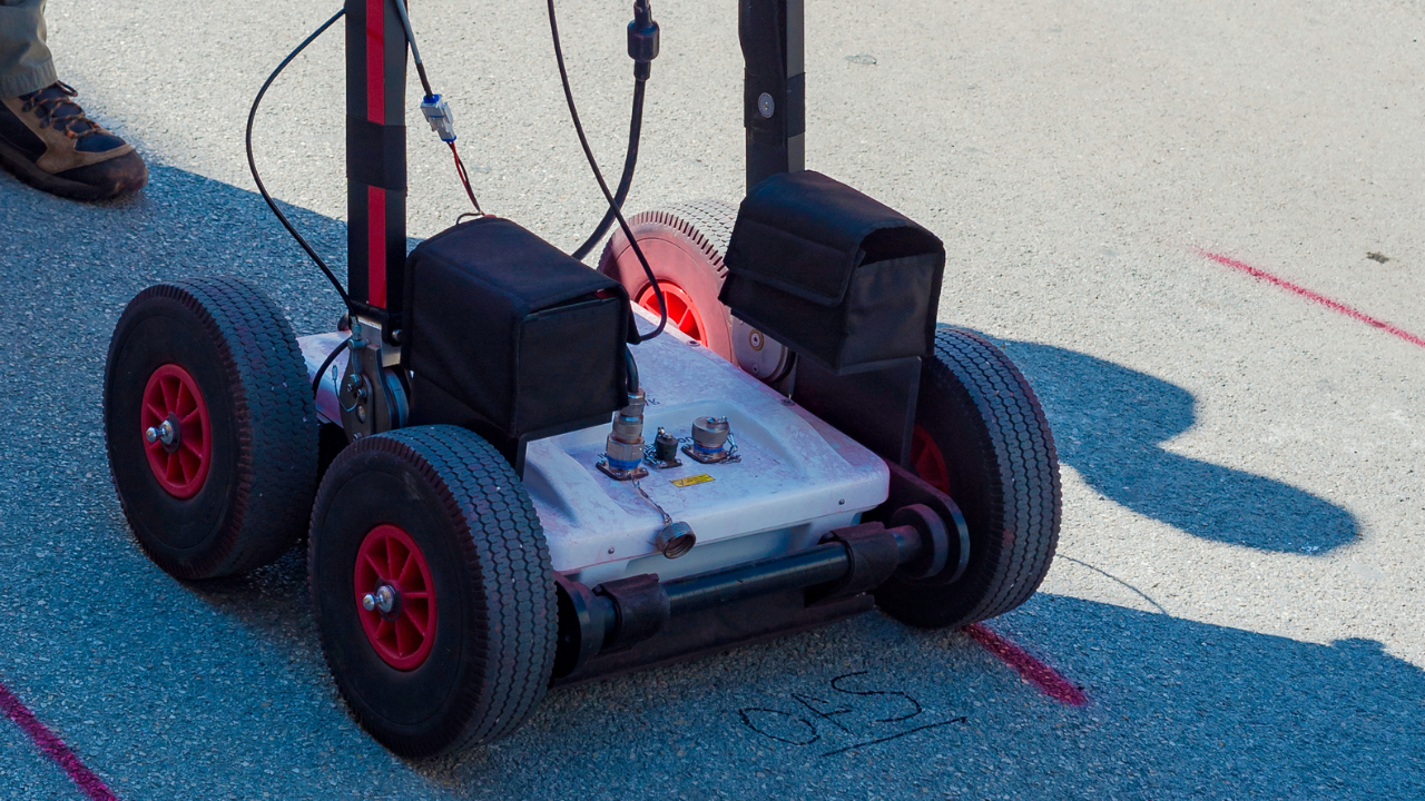
Utility locating requires precision and efficiency. Potholing for underground utilities ensures safety, but the process can be time-consuming. Ground Penetrating Radar (GPR) streamlines potholing by providing accurate underground mapping before excavation begins.
GPR emits radar pulses that penetrate the ground, detecting subsurface structures. This non-destructive method identifies the exact locations of underground utility lines. By using GPR before vacuum excavation potholing, teams can minimize disruptions and avoid unknown utilities.
The Advantages of GPR in Potholing Services
Accurate Utility Detection
GPR is a highly effective tool for identifying underground utilities before excavation begins. By detecting variations in subsurface materials, it provides a detailed map of underground utility lines, reducing the chances of accidental damage.
- GPR detects underground structures without physically disturbing the ground.
- It helps differentiate between various utility lines, such as gas lines, water pipes, and electrical conduits.
- The technology can locate utilities buried at different depths, ensuring a comprehensive underground assessment.
Reducing Risks and Costs
Accidental utility strikes during excavation can lead to costly repairs, project delays, and safety hazards. GPR minimizes these risks by offering precise data on underground conditions, ensuring excavation teams work with confidence.
- Prevents damage to public and private utilities, reducing costly repairs and service disruptions.
- Enhances worker safety by identifying high-risk areas before digging begins.
- Lowers overall project costs by improving efficiency and reducing unexpected obstacles.
Complementing Vacuum Excavation
Potholing utilities using vacuum excavation is an essential step in safe digging practices. GPR enhances this process by pinpointing exact locations, allowing vacuum excavation to be performed with greater accuracy.
- GPR helps guide vacuum excavation, reducing unnecessary digging and ensuring precision.
- The combination of GPR and vacuum excavation minimizes environmental disturbances and property damage.
- By reducing the number of test holes required, the excavation process becomes faster and more cost-effective.
Supporting Utility Mapping
A well-mapped underground infrastructure is crucial for successful excavation and construction projects. GPR provides valuable data that enhances utility mapping, making it easier for engineers and contractors to plan their projects.
- GPR produces high-resolution images of underground features, supporting surveying mapping.
- Utility companies can maintain accurate records of underground utility locations, reducing future excavation risks.
- GPR helps in long-term infrastructure planning by providing essential data for city development projects.
GPR in Different Excavation Projects
Construction Planning
- GPR assists construction teams in avoiding subsurface obstacles.
- It detects high-conductivity materials, helping engineers plan safe excavation routes.
Concrete Scanning and Inspection
Subsurface Investigation
- Geophysical methods like GPR help detect unknown utilities and underground anomalies.
- This technology supports environmental assessments and engineering geophysics.
The Role of GPR in Environmental and Geophysical Studies
Environmental Assessments
GPR is an essential tool in environmental studies, helping detect underground contaminants, leaks, and other hazards that may affect ecosystems and water sources. By mapping soil composition and groundwater movement, GPR supports land-use planning and environmental remediation efforts.
- GPR helps identify areas of soil contamination, allowing for targeted clean-up efforts.
- It detects underground storage tanks and pipelines that may pose environmental risks.
- The technology provides data on groundwater levels, assisting in water management and conservation projects.
Archaeological and Historical Site Surveys
Archaeologists and historians use GPR to uncover hidden structures and artifacts without disturbing the ground. This non-intrusive method preserves fragile historical sites while providing detailed underground maps.
- GPR helps locate buried foundations, walls, and artifacts, reducing the need for extensive digging.
- It allows researchers to map entire historical sites before excavation begins, preserving delicate structures.
- The technology aids in restoration projects by revealing hidden features of historical buildings and settlements.
Optimizing Infrastructure Maintenance with GPR
Roadway and Bridge Inspections
GPR is widely used in transportation infrastructure to detect structural weaknesses and deterioration in roads and bridges. It enables engineers to assess conditions and plan maintenance before small issues turn into costly repairs.
- GPR identifies voids, cracks, and weaknesses in roads and bridges before they deteriorate.
- It helps engineers assess the condition of pavement layers and underlying materials.
- The technology aids in planning repairs and maintenance without unnecessary excavation.
Utility Infrastructure Monitoring
GPR helps utility companies monitor and maintain their infrastructure, preventing costly failures and service disruptions. By detecting underground issues before they escalate, GPR supports proactive maintenance strategies.
- GPR tracks the condition of buried pipelines, detecting leaks or damage before major failures occur.
- It assists in evaluating the lifespan of underground infrastructure, allowing proactive maintenance.
- The method supports asset management by providing accurate data on existing utility networks.
Enhancing GPR Efficiency Through Advanced Geophysical Methods
Modern advancements in geophysical methods have improved GPR's ability to detect subsurface structures with higher accuracy. By incorporating techniques such as surface geophysical analysis, electromagnetic energy applications, and cross-borehole radar, engineers and utility companies can enhance underground utility locating.
- Surface Geophysical Methods: GPR complements surface-geophysical methods by integrating radar signals with seismic refraction tomography, improving underground imaging.
- Electromagnetic Energy: GPR transmits radar waves that interact with subsurface materials, reflecting signals based on electrical permittivity and conductivity.
- Cross-Borehole Radar: This method enhances subsurface intrusive investigations by transmitting electromagnetic pulses between boreholes to assess underground conditions in greater detail.
- Receiver and Transmitter Antennas: The use of idealized wave arrivals in receiver and transmitter antenna configurations optimizes penetration depth and accuracy in detecting underground services.
- Time-Distance Analysis: By utilizing a time-distance model (e.g., one-dimensional trace analysis), engineers can refine the interpretation of radar waves for more precise underground mapping.
- Industrial Clusters and Infrastructure Planning: GPR aids in the development of industrial clusters by providing valuable insights into subsurface conditions for large-scale construction projects.
GPR also plays a role in environmental geophysics research, with publications from the Journal of Applied Geophysics, Geophysical Research Letters, and Cambridge University Press showcasing advancements in utility locating services.
Ensure Safe and Precise Utility Locating with Bess Utility Solutions
Excavation without proper utility locating poses serious risks. Bess Utility Solutions combines state-of-the-art technology in utility locating with expert potholing services. Our team ensures precise detection, minimizing project delays and damage to underground utilities.
For expert potholing solutions, contact Bess Utility Solutions today at (408) 988-0101 for a Free Quote!