Hayward, CA
Fresno, CA
Orange, CA
Sacramento, CA
Phoenix, AZ
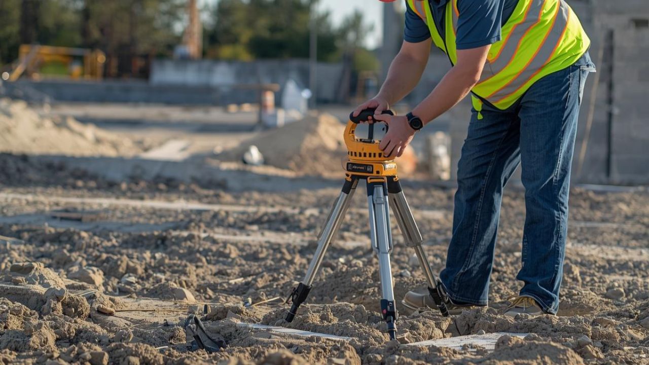
Ground penetrating radar accuracy for utility detection ranges from approximate location awareness to survey-grade precision, depending on methodology and project investment. California engineers managing infrastructure projects face subsurface complexity that demands understanding how detection accuracy, quality levels, and workflow integration affect strike prevention and design certainty.
The California construction market generated USD 158 billion in state GDP during 2024, supporting 922,400 workers across excavation-intensive projects. Nearly 38% of utility damages in 2023 resulted from failure to use the 811 notification system, demonstrating that technology choice directly impacts safety outcomes, schedule control, and liability exposure in underground utilities management.
Key Takeaways
Ground penetrating radar uses electromagnetic wave propagation to detect subsurface targets and estimate depth through reflected signal analysis. The technology differs fundamentally from electromagnetic locating by imaging soil interfaces and detecting both metallic and non-metallic objects rather than tracing energized conductive lines.
Electromagnetic field locating applies transmitter-generated signals to metallic utilities and uses receivers to trace electromagnetic responses along conductive paths. This method dominated 44.5% of global utility locator revenue in 2023 because it provides the lowest-cost access to metallic line detection.
Electromagnetic locators deliver strong performance on energized or traceable metallic infrastructure, but cannot detect non-metallic PVC or HDPE unless tracer wire exists. The technology provides narrow detection capability compared to GPR's broader target range but maintains commercial leadership through cost advantage and operational simplicity.
Ground penetrating radar systems transmit high-frequency electromagnetic pulses into soil and record reflected signals to generate subsurface images showing depth and target geometry. GPR equipment costs range from USD 14,000 for basic systems to USD 100,000 for premium multi-channel platforms with integrated positioning.
Stand-alone GPR performance remains sensitive to soil conditions, including clay content, moisture levels, and salinity, that affect signal penetration and resolution quality. The technology carries higher equipment and training costs than electromagnetic methods while delivering a lower success probability unless favorable site conditions and skilled interpretation combine effectively.
Subsurface Utility Engineering represents a process framework combining records research, surface geophysics, survey control, and verification exposure rather than a single technology. The SHRP2 Oregon DOT case study demonstrated that multi-channel GPR and time-domain electromagnetic induction together compensate for individual method weaknesses through complementary detection capabilities.
Integrated workflows establish survey control for georeferenced field data and incorporate GNSS positioning to support GIS-based 2D and 3D visualization platforms. Combined mapping solutions deliver engineering-grade documentation that single-method approaches cannot provide because they merge detection, positioning, and verification into quality-controlled deliverables.
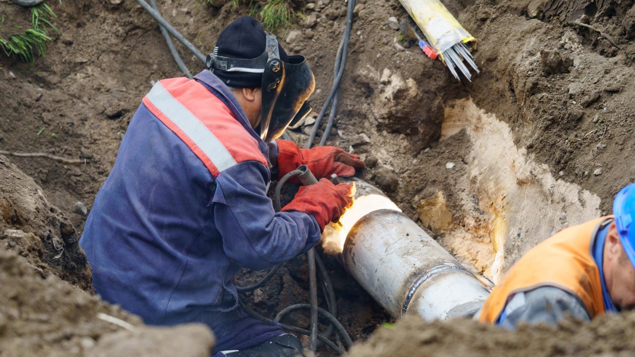
California construction projects face excavation risk intensified by infrastructure density, aging utility networks, and incomplete or inaccurate as-built documentation. Accurate utility detection directly prevents work stoppages, injury events, service disruptions, and financial liability that threaten project outcomes and professional responsibility.
Infrastructure density in California urban corridors creates strike-prevention challenges where buried asset congestion increases contact probability during excavation. Schedule risk from utility conflicts causes project delays, change orders, and cost escalation when undocumented utilities appear during construction.
Design uncertainty from poor record quality forces engineers to make conservative assumptions that increase project costs or accept liability exposure from incomplete information. Safety incidents from utility strikes generate injury potential, regulatory penalties, and reputational damage extending beyond immediate financial consequences.
The 811 notification system establishes mandatory excavation planning and damage prevention protocols that require notification before digging activity begins. Failure to use 811 notification contributed to nearly 38% of California damages in 2023, demonstrating that procedural compliance alone does not eliminate strike risk.
California contractors identified workforce quality as a critical safety challenge, with 78% citing inexperienced skilled labor and workforce shortages. Technology adoption patterns shift toward methods that reduce operator dependency and provide verifiable documentation when project teams lack experienced field personnel.
Quality Level B uses surface geophysical methods to determine the existence and horizontal position of utilities without excavation or exposure verification. Quality Level A requires nondestructive exposure through vacuum excavation or other test hole methods and yields the highest-confidence horizontal and vertical position data.
QL-A vertical plan data typically achieves approximately 15 mm vertical accuracy when combined with proper survey control and mapping procedures. Stakeholder research across 85 utility industry participants found that serious users expect location tolerances better than 100 mm to depths of 3 meters for routine work and 5 meters for deeper infrastructure.
California utility detection demand varies geographically between northern and southern territories due to infrastructure age, urban density patterns, and excavation activity concentration. Seasonal construction cycles influence scanning demand, with spring and summer peaks corresponding to favorable weather and municipal project schedules.
DigAlert serves nine Southern California counties, including Los Angeles, Orange, Riverside, San Bernardino, San Diego, Santa Barbara, Ventura, Imperial, and Inyo. The USA North territory and DigAlert territory split excavation notifications approximately 58.2% to 41.8% through October 2024, indicating comparable activity levels across California regions.
Los Angeles and Bay Area markets both feature dense urban utility environments requiring multi-method detection capabilities and high-confidence documentation. Southern California concentrates major transportation corridor work, while northern markets emphasize technology sector infrastructure and municipal utility modernization projects.
Dense urban environments in San Francisco, Los Angeles, Oakland, and San Jose demand higher-confidence mapping because buried asset congestion and critical facility adjacency increase strike consequences. Urban projects justify premium detection methods through disruption cost avoidance and liability exposure management that exceed equipment investment.
Suburban and lower-density construction contexts maintain higher price sensitivity, where basic electromagnetic locating provides acceptable risk management for routine metallic utility environments. Technology selection shifts toward integrated workflows when project specifications require engineering-grade deliverables, regardless of geographic setting or infrastructure density.
California 811 ticket volume demonstrates clear seasonal patterns with winter lows advancing into stronger spring and summer activity levels. Late summer and early fall typically show peak excavation notification volumes, especially in the USA North territory serving Bay Area markets.
Seasonal demand patterns align with municipal budget cycles, favorable weather windows, and construction scheduling preferences that concentrate infrastructure work during dry months. Technology providers experience capacity constraints during peak periods, making early project planning and service reservation important for time-sensitive work.
California construction decision-making involves contractor-led procurement with engineering influence on higher-specification projects requiring documented subsurface intelligence. Professional role distribution, digital adoption patterns, and workforce characteristics shape technology preferences across project types and organizational contexts.
California contractor mix includes 52% general contractors and construction managers, 25% specialty contractors, 13% suppliers and services, 5% owners and developers, and 3% architects, engineers, and designers. This distribution indicates that contractor perspectives dominate purchasing decisions while engineering requirements influence specification and quality expectations.
Digital adoption data shows 67% of California contractors use daily field reports, 59% track time digitally, 57% access field job information electronically, 49% share documents through cloud platforms, and 22% generate compliance reporting. Technology preferences favor solutions that integrate field data capture with documentation workflows already established in contractor operations.
Software-enabled utility mapping platforms deliver cloud storage, GNSS integration, and GIS-based visualization that support project collaboration and regulatory documentation requirements. Digital integration's importance grows as projects demand handoff quality, auditability, and repeatable access to subsurface intelligence beyond temporary paint marks.
The GTI Energy case study demonstrated that field staff could transition to integrated digital utility mapping systems with only 1-2 days of training. Additional device support could be added in approximately 1-2 weeks, plus testing time, indicating implementation barriers remain manageable for organizations prioritizing documentation quality.
The median construction worker age stands at 42 years, with 67.3% of workers aged 35-54 across the construction sector. Mid-career decision makers and field leaders represent primary technology adoption influencers, while usability requirements must address younger crew members entering the workforce.
Workforce shortage pressures reported by 78% of California contractors create demand for technologies that reduce training requirements and operator dependency. Systems providing clearer visual outputs, automated interpretation assistance, and digital documentation reduce skill gaps while maintaining detection quality standards.
Utility detection cost structure spans budget electromagnetic equipment to premium integrated service packages, depending on project requirements and accuracy expectations. Price comparison must account for equipment purchase versus rental options, service-provider engagement, and total project value relative to strike-prevention benefits.
Budget-tier electromagnetic locators cost approximately USD 5,000 for purchase or USD 300 per week for rental access. Mid-tier GPR systems range from USD 14,000 to USD 30,000, while premium multi-channel platforms reach USD 30,000 to USD 100,000 or higher.
Integrated service packages, including two-technician crews, multi-method detection, and survey-grade documentation, cost approximately USD 3,360 per day in representative California markets. Service pricing reflects professional expertise, equipment investment, insurance requirements, and deliverable quality that individual equipment purchases cannot replicate.
Purdue University's analysis of 71 highway projects found average Subsurface Utility Engineering savings of approximately 4.6% of total construction cost. Typical SUE savings reach 10% to 15% of construction cost through conflict avoidance, redesign elimination, and change-order reduction.
Later ROI analysis demonstrated average returns of USD 12.23 for every USD 1.00 spent on SUE across transportation infrastructure projects. Economic benefits derive from preventing costly utility relocations, avoiding emergency repairs, eliminating schedule delays, and reducing claims and liability exposure.
Premium utility mapping investment delivers measurable returns when excavation damage costs, service disruption consequences, or design uncertainty risks exceed detection and mapping expenditures. Projects involving critical infrastructure adjacency, congested utility environments, or high public visibility justify advanced detection methods through risk-adjusted cost comparison.
Claims and liability from excavation damage can reach millions of dollars for major utility strikes affecting power distribution, telecommunications networks, or natural gas transmission. Service disruption costs from utility damage extend beyond repair expenses to include business interruption, emergency response mobilization, and regulatory enforcement actions.
Utility detection accuracy depends on method selection, site-specific conditions, operator skill, and quality level definitions rather than equipment specifications alone. California engineers should evaluate accuracy claims within the context of project requirements, verification methods, and documented performance evidence from comparable applications.
Ground penetrating radar performance varies significantly based on soil moisture content, clay concentration, utility burial depth, target diameter, and electromagnetic interference from adjacent infrastructure. Signal attenuation in clay-rich soils limits penetration depth and target resolution compared to sandy or gravelly conditions with low moisture.
Operator interpretation skill affects target identification accuracy because GPR generates raw signal data requiring analysis to distinguish utilities from soil features and non-utility objects. Technology improvements in automated processing and artificial intelligence analysis reduce but do not eliminate the importance of experienced operators for reliable utility detection outcomes.
Quality Level B provides surface geophysical detection of utility existence and approximate horizontal position without physical verification through excavation or exposure. QL-B accuracy depends entirely on geophysical method performance under site-specific conditions and cannot deliver survey-grade vertical position data without test holes.
Quality Level A requires nondestructive exposure to visually confirm utility presence, measure precise depth, and verify horizontal position through survey control. QL-A vertical accuracy typically achieves approximately 15 mm precision when proper survey methods and mapping protocols are applied to exposed utility locations.
Software platforms for utility mapping depend fundamentally on field data quality captured by equipment operators working under actual site conditions. Automated processing cannot compensate for poor data collection, inadequate site preparation, or insufficient scan density in complex utility environments.
Effective GPR use requires operators who understand signal propagation physics, recognize soil interference patterns, and adapt scanning parameters to site-specific conditions. Training requirements for competent GPR operation exceed basic equipment operation because interpretation accuracy determines whether detected anomalies represent actual utilities or subsurface artifacts.
Method selection should prioritize project-specific requirements, including utility type, infrastructure complexity, accuracy expectations, and consequence analysis, rather than default technology preferences. California engineers should evaluate whether electromagnetic limitations create unacceptable risk exposure before defaulting to the lowest-cost detection approaches.
Projects involving unknown non-metallic utilities, poor record quality, congested urban corridors, or design-phase conflict reduction benefit from GPR or combined detection workflows. Advanced methods become necessary when electromagnetic locating cannot address project requirements because target utilities lack metallic components or tracer wire installation.
Stand-alone methods provide incomplete information compared to integrated SUE workflows that combine multiple detection technologies with records research and verification exposure. Complex projects with high strike consequences or tight schedule constraints require multi-method approaches that compensate for individual technology limitations through complementary detection capabilities.
Urban utility congestion creates electromagnetic signal interference and multiple target overlap that reduces single-method locating effectiveness and increases false-positive rates. Non-metallic utility prevalence in modern water, sewer, and communications infrastructure demands detection methods capable of imaging dielectric contrasts rather than tracing conductive paths.
The directional 2024 market split of approximately 47% electromagnetic, 45% GPR, and 8% other methods reflects growing recognition that precision locating requirements exceed basic metallic line tracing. California engineers working in dense infrastructure environments increasingly specify multi-method approaches that address both metallic and non-metallic detection requirements within single project scopes.
Software-integrated platforms combine field detection devices with GNSS positioning, cloud storage, and GIS visualization to create persistent digital utility records beyond temporary surface markings. Digital utility data supports design coordination, construction planning, and long-term asset management through structured information that survives project completion and personnel turnover.
GPR data platforms enable collaboration across engineering, construction, and operations teams by providing shared access to verified subsurface information in map-based formats. Regulatory compliance documentation, liability protection, and institutional knowledge preservation depend increasingly on digital utility intelligence rather than paper as-built drawings or field notes.
California engineers should establish accuracy requirements based on project consequences and verification investment rather than assuming all detection methods deliver equivalent results. The choice between electromagnetic locating, GPR scanning, and integrated utility mapping workflows determines whether projects achieve basic awareness, operational confidence, or engineering-grade certainty about subsurface conditions.
Stakeholder research demonstrates that serious utility detection users expect location tolerances better than 100 mm to depths of 3 meters for routine infrastructure work. These accuracy expectations align with Quality Level A requirements that combine geophysical detection, survey control, and nondestructive exposure to deliver approximately 15 mm vertical precision.
Successful utility detection outcomes depend on matching method selection to project conditions, investing in operator training, and accepting that premium approaches deliver measurable ROI through strike prevention and conflict avoidance. California's construction environment—with nearly 38% of damages linked to 811 notification failures—demonstrates that procedural compliance alone cannot substitute for accurate subsurface intelligence.
Organizations managing California infrastructure projects should evaluate detection technology based on risk-adjusted value rather than equipment cost alone. Bess Utility Solutions has demonstrated through 29 years of continuous operation that precision locating and ASCE 38-02 compliant processes prevent costly strikes while supporting schedule certainty for construction superintendents, engineering project managers, and public works directors.
California engineers require detection partners who understand that subsurface uncertainty creates design liability, schedule exposure, and safety consequences extending far beyond immediate project budgets. The value of accurate utility detection emerges not from finding buried lines but from eliminating uncertainty before uncertainty becomes damage, delay, cost escalation, or liability.
Understanding GPR accuracy is the first step. Partnering with the right team is what protects your project, your budget, and your crew.
Bess Utility Solutions combines Ground Penetrating Radar, electromagnetic locating, and vacuum excavation (potholing) into one integrated workflow — delivering the Quality Level A accuracy that California engineers and contractors rely on. As a CPUC-certified MBE/DBE firm with over 29 years of experience and 1,000+ satisfied clients, we provide the verified subsurface data you need to design, plan, and build with confidence. Contact Bess Utility Solutions today for a consultation — and take the guesswork out of what's underground.
Pricing Disclaimer:
The pricing information referenced in this article is intended for general guidance only and is subject to change without notice. Costs may vary depending on factors such as project size, site conditions, accessibility, and required services. For precise pricing and a tailored quotation, please contact Bess Utility Solutions directly to discuss your project requirements.