Hayward, CA
Fresno, CA
Orange, CA
Sacramento, CA
Phoenix, AZ
GPR scanning uses radar-based imaging to detect buried utilities before excavation, reducing strike risk across California construction sites. Electromagnetic locating complements GPR by tracing metallic lines through frequency-based detection, creating a two-method approach that addresses the full spectrum of underground infrastructure. California's dense urban corridors and aging utility networks make preconstruction scanning essential for project continuity and safety. The state's Underground Safety Board reports that nearly 38% of damages in 2023 resulted from failure to use the 811 notification system, demonstrating the preventable nature of most utility strikes.
Key Takeaways
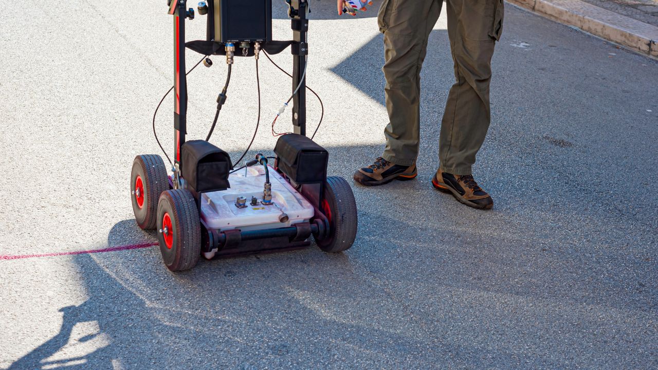
GPR scanning transmits electromagnetic pulses into the ground and records reflected signals to identify subsurface objects and depth. The technology detects both metallic utilities, such as steel gas lines, and non-metallic infrastructure, including PVC water mains and HDPE storm drains. Electromagnetic locating applies a transmitted frequency to conductive utilities and uses a receiver to trace the signal path along metallic infrastructure. This workflow excels at tracing copper telephone lines, steel pipes, and aluminum conduit, but requires tracer wire or indirect energizing for non-conductive targets.
California construction contributed USD 158 billion to the state's GDP in 2024 and supported 922,400 workers as of August 2024. Private nonresidential spending reached USD 34 billion in 2023, while state and local construction spending totaled USD 46 billion during the same period. Failure to use the 811 notification system contributed to nearly 38% of damages in 2023, creating avoidable project delays and safety incidents. Utility strikes disrupt service to critical facilities, trigger regulatory investigations, and generate claims that exceed the cost of utility locating services, preventing accidents multiple times over.
Electromagnetic locating effectively traces metallic utilities, while GPR scanning detects both metallic and non-metallic targets, including fiber optic conduit and plastic storm drains. EM locating carries a lower upfront cost at approximately USD 5,000 for purchase, versus GPR systems ranging from USD 30,000 to USD 100,000 or more. EM locating delivers fast results for standard field work, whereas GPR requires more interpretation skill and analysis time. Budget considerations place EM around USD 5,000 for basic units, while premium GPR systems exceed USD 100,000 depending on channel count and software integration.
EM locator purchase costs approximately USD 5,000, with rental options available for near USD 300 per week. Electromagnetic field (EMF) technology represented 44.5% of global utility locator revenue in 2023, confirming its position as the most widely adopted detection method. Projects with primarily metallic infrastructure and limited budgets achieve cost-effective surveying outcomes through EM-based workflows. Contractors managing routine excavation around known metallic utilities often find EM locating sufficient for compliance and safety requirements.
EM locating performs weakly on non-metallic PVC or HDPE unless tracer wire exists or indirect energizing is possible. GPR performance varies with soil conditions, operator skill, and project fit, making site evaluation critical before equipment selection. GPR probability of success can fall below other methods unless favorable project conditions exist, including low-clay soils and adequate target depth. GPR effectiveness declines in clay-rich soils where signal attenuation reduces penetration depth and target clarity, while operator interpretation skill directly influences detection accuracy.
Strike prevention risk escalates in dense urban environments where underground congestion creates spatial conflicts and limited excavation tolerance. Service disruption from utility strikes impacts residential neighborhoods, commercial districts, and transportation networks with cascading economic consequences. Claims and liability from excavation damage generate costs that include emergency repairs, regulatory fines, third-party damages, and schedule delays. California's major metropolitan areas, including Los Angeles, San Francisco, Oakland, and San Jose, present the highest-density utility environments where GPR improves safety in excavation construction, becoming most critical.
The SHRP2 Oregon DOT case study combined multi-channel GPR and time-domain electromagnetic induction to compensate for each method's detection gaps. Stand-alone methods provide baseline detection, while integrated SUE workflows deliver higher confidence levels through complementary technologies and verification protocols. Multi-method approaches reduce false negatives by applying GPR where EM cannot energize non-metallic lines and using EM to confirm GPR interpretations on conductive targets. Combined detection workflows support proper utility mapping to avoid construction risks through layered field validation.
SUE is a process combining engineering judgment, geophysics, surveying, and records research rather than a single technology. QL-B uses surface geophysical methods to determine the existence and horizontal position of utilities without excavation. QL-A requires nondestructive exposure and yields the highest-confidence horizontal and vertical information, typically achieving 15 mm vertical accuracy. Records research precedes field scanning in SUE workflows to focus detection efforts on high-risk corridors and update outdated as-built documentation, while quality levels guide verification planning based on ASCE 38-22 SUE standards and utility locating protocols.
Staff can transition to digital utility systems with 1–2 days of training, reducing the learning curve for field crews. Additional device support can be added within 1–2 weeks, plus testing, allowing gradual platform expansion. Basic locating provides paint marks that fade over time, whereas software platforms create permanent digital records with coordinate data and depth attributes. Software platforms introduce training burdens and require consistent field-data quality to maintain system integrity. Digital systems depend on accurate GNSS input and disciplined field procedures to deliver reliable GIS-ready deliverables.
Stakeholders in an 85-response survey wanted location tolerances better than 100 mm for critical infrastructure detection. Depth requirements typically extend to 3 meters and sometimes reach 5 meters for deeper utilities and design conflict analysis. QL-A vertical plan data typically achieves approximately 15 mm vertical accuracy plus applicable horizontal survey precision. A 2024 California contractor survey found that 78% cited inexperienced skilled labor and workforce shortage as the primary safety challenge, making the advantages of using vacuum excavation and verification exposure increasingly valuable.
USA North territory accounted for 58.2% of California 811 activity through October 31, 2024, reflecting Northern California's excavation volume. DigAlert territory represented 41.8% of California 811 activity during the same period, covering southern California's dense construction market. USA North territory covers northern California and Nevada for 811 notifications, extending beyond state boundaries. DigAlert covers nine Southern California counties, including Los Angeles, Orange, Riverside, San Bernardino, San Diego, Santa Barbara, Ventura, Imperial, and Inyo, representing the state's highest-density urban corridor, while homeowner shares consistently stayed below 5% of 811 tickets.
Utility GPR systems range from approximately USD 14,000 to USD 100,000 or more, depending on sophistication and channel count. Average SUE savings reached 4.6% of total construction cost across 71 highway projects in documented case studies. SUE ROI averaged USD 12.23 for every USD 1.00 spent on preconstruction utility engineering and field verification. Typical SUE savings range from 10% to 15% of project cost through redesign avoidance and conflict resolution. Integrated two-technician packages cost approximately USD 3,360 per day, representing the premium service tier where outsourcing replaces equipment ownership.
Underground utility locating through GPR scanning and electromagnetic methods prevents excavation damage that would otherwise halt construction schedules and trigger regulatory investigations. California construction sites benefit from combined detection workflows that address both metallic and non-metallic infrastructure across diverse soil conditions. Strike prevention through accurate subsurface mapping reduces emergency repair costs, third-party liability claims, and service disruptions that affect public safety. Projects employing SUE workflows and verification exposure achieve higher confidence levels than records-based approaches, particularly in dense urban environments where GPR vs EM locating technology for your project selection requires careful evaluation of soil type, utility mix, and consequence of error.
California construction professionals managing infrastructure projects must balance upfront scanning costs against the financial and operational risks of utility strike prevention failures. The state's regulatory environment and urban density create conditions where advanced detection technologies deliver measurable ROI through change-order reduction and schedule protection. Bess Utility Solutions provides comprehensive subsurface mapping services across California's major construction markets, combining electromagnetic locating, GPR scanning, and verification exposure under ASCE 38-22 compliant workflows. Accurate utility data protects project budgets, maintains excavation safety, and supports informed design decisions that prevent costly conflicts.
Protect your next California construction project with professional utility locating and subsurface engineering services that combine proven detection methods, survey-grade accuracy, and regulatory compliance experience.
Don't leave underground safety to chance. Bess Utility Solutions provides professional GPR scanning and electromagnetic locating services across California, giving your project the subsurface clarity it needs before the first shovel hits the ground. Whether you're navigating a dense urban corridor in Los Angeles or managing mixed-utility infrastructure across a large commercial site, our certified technicians deliver accurate, GIS-ready utility maps that keep your crew safe and your schedule on track. Contact Bess Utility Solutions today to schedule a pre-construction utility scan — and excavate with confidence.


