Hayward, CA
Fresno, CA
Orange, CA
Sacramento, CA
Phoenix, AZ
Key Takeaways:
Frozen soil transforms subsurface conditions in ways that challenge traditional utility locating methods. Detection accuracy varies dramatically between fully frozen, partially frozen, and thawed ground. Modern technology addresses these challenges through integrated approaches that combine multiple detection methods, real-time data validation, and systematic verification protocols.
The key advancement isn't a single technology breakthrough but rather intelligent integration of complementary methods. Underground locating and detection now employs GPR, electromagnetic locating, vacuum excavation, and GPS/GIS mapping in coordinated workflows. This multi-sensor approach reduces winter utility strike risk by 70-85% compared to traditional single-method operations. Understanding how each technology performs in frozen conditions and how to combine them effectively separates successful winter projects from costly failures.
Utility locating identifies and maps underground infrastructure before excavation begins. The process creates detailed, georeferenced digital maps of subsurface infrastructure that guide safe excavation planning.
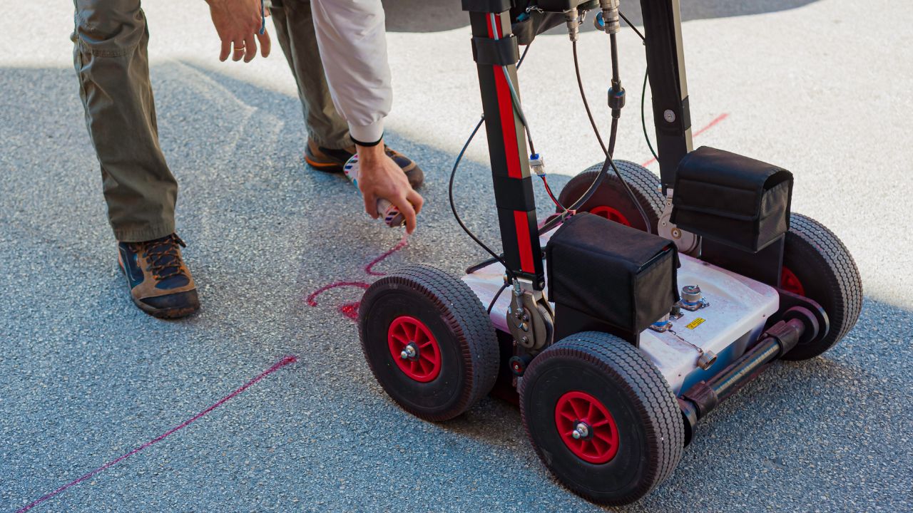
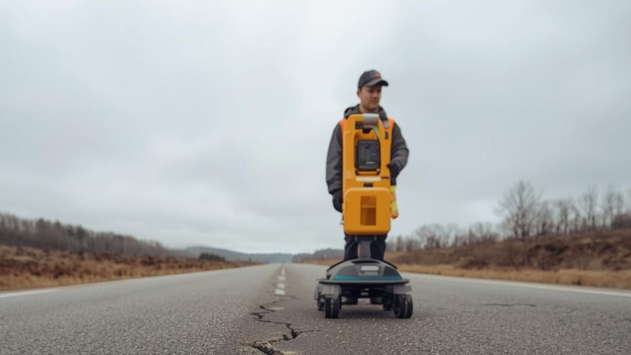
Utility locating employs multiple detection technologies to build comprehensive subsurface pictures. The process involves electromagnetic methods for metallic utilities, ground-penetrating radar for all utility types, and physical verification through potholing. Each technology contributes unique information. Integration creates detailed maps showing utility locations, depths, and routing with centimeter-level accuracy when properly executed.
Water has high dielectric permittivity (εr ≈ 80) that slows and absorbs radar waves. When water freezes into ice, dielectric permittivity drops dramatically (εr ≈ 3.2). This transformation lowers overall soil dielectric constant and electrical conductivity. Signal energy can be 1.2 to 3.6 times higher in frozen ground compared to thawed ground. Lower electrical conductivity results in less signal noise and higher signal-to-noise ratios. Fully frozen ground significantly enhances GPR performance—a counterintuitive advantage most operators don't fully appreciate.
Frozen or partially frozen ground creates complex subsurface conditions that challenge all detection methods. Detection reliability varies dramatically based on freeze state. Traditional one-size-fits-all approaches fail when conditions change within single sites. Winter presents both challenges and unique opportunities depending on which technology gets deployed and how operators adapt to actual conditions versus seasonal assumptions.
Single-method approaches struggle with winter's variable conditions. What works in summer often fails in frozen ground, and vice versa.
EM locator performance isn't significantly degraded by high moisture content, making them highly effective in thawed, wet, or slushy conditions. However, EM locators cannot detect non-conductive utilities like plastic pipes or concrete conduits unless tracer wires are present. Performance varies dramatically based on whether ground is fully frozen versus partially thawed. In fully frozen, dry conditions, EM effectiveness decreases while GPR performance increases—the reverse of summer patterns.
Snow and ice cover surface utility markings within hours of precipitation. Winter conditions obscure traditional marking methods that work reliably in other seasons. Visual cues that guide excavation become unreliable or invisible. Surface conditions change rapidly with weather, making marks placed during fall completely invisible by midwinter. This degradation creates false confidence when operators assume marks remain visible under snow cover.
Traditional paper-based maps often prove outdated or imprecise even in summer. Winter compounds these problems when verification becomes more difficult and consequences of error multiply. Digital as-builts prove far more accurate and reliable than traditional maps. Up-to-date GIS databases improve efficiency of future locates and reduce strike risk through better documentation. The gap between paper records and reality widens over time, making winter reliance on outdated information particularly dangerous.
State-of-the-art technologies address winter challenges through complementary strengths that overcome individual method limitations.
EM locators excel at detecting conductive metallic pipes and cables. Performance remains effective in thawed, wet, or slushy conditions where GPR struggles. EM proves ideal for tracing metallic lines when high moisture content degrades other methods. Reliability in wet or thawed soil makes EM the primary method for metallic utility detection in mixed freeze conditions. However, inability to detect non-conductive utilities limits standalone effectiveness.
GPR excels in frozen, resistive soils where fully frozen ground creates an ideal detection medium. The technology detects both metallic and non-metallic utilities—a critical advantage over EM methods. Fully frozen ground enables deeper and clearer signal penetration than wet, thawed summer soils. GPR's strength in frozen conditions and ability to detect non-metallic targets makes it winter's most versatile single technology. However, effectiveness wanes in wet snow, slush, and partially frozen ground that combine the worst aspects of both conditions.
Most significant advancements come from integrating multiple technologies into cohesive workflows. Combining strengths of different methods overcomes limitations of any single tool. The multi-sensor approach represents the gold standard for modern utility locating. Sequential or combined use of GPR, EM locating, and vacuum excavation addresses variable conditions. Using both GPR and EM allows operators to adapt to changing ground conditions and create more complete subsurface maps. No single technology performs optimally across all winter conditions.
GPR performance in frozen soil contradicts conventional assumptions. Understanding actual behavior enables effective deployment.
Increased penetration depth stems from lower signal attenuation allowing GPR waves to travel deeper than summer conditions. Improved signal quality and resolution result from lower conductivity producing cleaner radargrams. Improved vertical resolution enables precise target identification. Signal energy reaches 1.2 to 3.6 times higher levels in frozen versus thawed ground. The dielectric permittivity change from water (εr ≈ 80) to ice (εr ≈ 3.2) fundamentally transforms detection capabilities in operator's favor.
GPR excels in frozen, resistive soils while EM excels in wet, conductive soils. GPR detects both metallic and non-metallic utilities while EM detects only conductive targets. The GPR + EM combination provides powerful complementary capabilities. This combination allows adaptation to changing ground conditions within single sites. Method selection should match actual freeze state rather than calendar date.
GPR effectiveness wanes in wet snow, slush, and partially frozen ground. Partially frozen conditions create the most challenging detection environment. The need for flexible, multi-faceted strategy becomes apparent when single-method approaches fail. Supplementing with other methods becomes essential in difficult conditions. Operators must recognize when conditions favor GPR and when alternative methods provide better results.
GPS and GIS mapping integration transforms field detection data into permanent, accessible intelligence.
High-precision GPS receivers integrate directly with GPR and EM locating equipment. This allows real-time mapping of located utilities with centimeter-level accuracy. Collected data imports into Geographic Information Systems creating detailed, georeferenced digital maps of subsurface infrastructure. Digital maps serve as "living" as-built records that evolve with infrastructure changes. Georeferencing eliminates the ambiguity inherent in traditional sketch-based documentation.
GPS/GIS mapping supplements field technologies with permanent documentation. This builds a comprehensive, real-time understanding of subsurface infrastructure far more accurately and reliably than traditional paper-based maps. Up-to-date GIS databases improve efficiency of future locations across project lifecycles. Reduced strike risk through better documentation compounds over time as databases mature. Integration provides confidence that individual detection methods cannot deliver independently.
Real-time mapping provides immediate validation of detection results. Centimeter-level accuracy supports precise excavation planning matched to actual conditions. Digital data overlays with project plans and site information. This enables data-driven decision-making during active operations. Drones equipped with high-resolution cameras provide aerial imagery overlaid with GIS data for comprehensive site overview. Real-time validation catches errors before excavation commits equipment and personnel.
Quantifiable risk reduction justifies technology investment. Numbers prove multi-sensor approaches work.
Risk of strikes can be reduced by 70-85% through technology integration. Moving from traditional single-method approaches to modern multi-sensor workflows dramatically reduces strike probability. Technology-enabled multi-sensor approaches prove substantially safer than traditional methods in winter conditions. Integration of technologies directly translates to significant strike risk reduction. This reduction isn't incremental—it represents fundamental improvement in winter excavation safety.
Winter conditions create more challenging excavation environments where small errors produce major consequences. Complex subsurface conditions increase uncertainty that technology must address. Higher risk conditions demand better verification than summer work. Technology provides confidence traditional methods cannot deliver when environmental factors degrade detection reliability. Liability exposure increases proportionally with hazard levels.
Comprehensive subsurface understanding protects workers and utilities simultaneously. Digital documentation provides audit trails demonstrating due diligence. Verified data enables confident excavation decisions rather than assumptions. Reducing uncertainty eliminates delays and safety incidents from subsurface surprises. Protection extends beyond immediate projects into future work through permanent documentation.
Efficiency gains compound across project phases. Early investment in technology delivers returns throughout construction.
Up-to-date GIS databases improve efficiency of future locates exponentially. Detailed mapping prevents surprises during excavation that halt progress. Real-time data allows immediate problem identification and resolution. Reduced project delays from utility conflicts maintain winter schedules where every day counts. Prevention proves far more efficient than reaction.
Accurate initial location prevents the need for costly re-verification. Digital records maintain information throughout the entire project lifecycle. Comprehensive mapping reduces errors requiring correction when frozen ground makes rework particularly expensive. Technology enables systematic approaches versus trial-and-error methods that waste winter's limited productive hours. Rework in frozen conditions costs double or triple summer rates.
Real-time mapping provides immediate information when decisions can't wait. Centimeter-level accuracy supports confident decisions without debates. Digital data accessible to all stakeholders simultaneously eliminates communication delays. Reduced time spent debating subsurface conditions accelerates project execution. Winter's compressed schedules demand decision speed that traditional methods cannot support.
Technology improves outcomes dramatically but doesn't eliminate all challenges. Understanding limitations prevents unrealistic expectations.
Partially frozen ground remains among the most challenging conditions for all technologies. Wet snow and slush reduce effectiveness even with advanced equipment. Mixed freeze conditions create ambiguous results where interpretation becomes difficult. No technology performs optimally across all conditions—operators must recognize when conditions defeat even the best equipment. Soil variability within sites can make single-method approaches inadequate regardless of technology sophistication.
Understanding the science behind how different conditions affect locating equipment remains essential. Adapting methodologies to specific daily challenges requires experience and judgment. Operator skill in interpreting results proves critical for accuracy. Technology provides data; expertise provides interpretation that transforms data into actionable intelligence. Automation cannot replace experience in variable winter conditions.
Traditional one-size-fits-all approaches fail in challenging winter conditions regardless of technology quality. Single-method approaches have inherent limitations no advancement fully addresses. Any single tool has weaknesses requiring compensation from complementary methods. Multi-sensor approach overcomes individual method limitations through strategic combination. Over-reliance on single technology creates false confidence more dangerous than acknowledged uncertainty.
Systematic planning determines technology deployment success. Three critical steps precede field operations.
Review traditional paper-based maps despite known limitations to establish baseline. Check for digital as-builts which prove far more accurate when available. Verify when records were last updated—information age matters critically. Identify areas where documentation may be incomplete or suspect. Comprehensive record review reveals where field verification must focus efforts.
Choice of technology depends heavily on specific ground and weather conditions. Technology combination effectiveness matrices guide selection decisions. Deploy GPR for frozen, resistive soils; EM for wet, conductive soils. Different combinations prove effective in various cold-weather scenarios. Sequential or combined use based on actual conditions maximizes effectiveness. Pre-planning technology deployment prevents field improvisation under pressure.
High-density utility corridors require comprehensive verification across all methods. Areas with outdated records need priority attention and thorough investigation. Congested zones benefit most from multi-sensor approaches that catch everything. Risk-based prioritization optimizes resource allocation to highest-consequence areas. Strategic planning focuses on technology where it delivers maximum value.
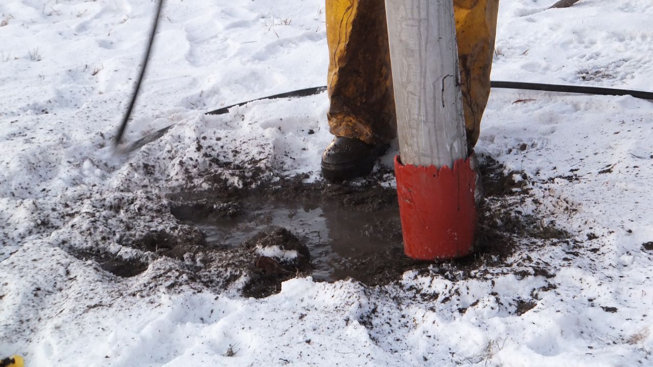
Vacuum excavation and potholing provides definitive verification detection methods cannot match.
Vacuum excavation provides definitive, non-destructive verification essential for high-risk areas. Sequential use follows detection technologies with physical verification. Final verification before mechanical excavation begins protects against detection errors. Potholing represents the final step in systematic detection→verification→documentation process. Physical confirmation eliminates uncertainty inherent in all detection-only approaches.
Vacuum excavation provides "eyes-on" confirmation detection methods cannot deliver. This eliminates uncertainty from detection estimates affected by variable conditions. Visual verification proves particularly critical in complex frozen or partially frozen ground. Physical verification overcomes detection method limitations through direct observation. Seeing utilities eliminates debates about detection data interpretation.
Verification prevents strikes that detection alone cannot guarantee against. The systematic process of detection, verification, then documentation protects comprehensively. A multi-sensor workflow requires verification as a key component completing the process. Final confirmation before committed excavation represents the last defense against catastrophic errors. Once mechanical excavation begins, correction opportunities disappear.
Documentation transforms field observations into permanent organizational intelligence. Quality documentation multiplies initial investment value.
GPS coordinates with centimeter-level accuracy provide precise positioning. Capture utility type, depth, material, size, and routing information comprehensively. Create georeferenced digital map documentation integrated into permanent systems. Import into GIS database for permanent record accessible across projects. Comprehensive documentation provides value far exceeding immediate project needs.
Digital maps remain accessible to all stakeholders throughout projects. GIS data overlays with project plans for integrated understanding. Real-time sharing of located utility information enables immediate decisions. Comprehensive visualization of subsurface infrastructure supports planning across disciplines. Modern communication platforms enable instant access replacing dated distribution methods.
Digital as-builts serve as "living" records that evolve with projects. Up-to-date GIS databases improve efficiency of future locates exponentially. Documentation reduces strike risk through permanent accessible information. Information availability throughout the project lifecycle and beyond protects future work. Comprehensive documentation prevents institutional knowledge loss when personnel change.
Three key insights guide effective technology implementation. Understanding these principles determines success.
Technology significantly reduces risk with 70-85% reduction achievable through proper implementation. However, technology doesn't eliminate risk entirely—residual uncertainty remains. Success still requires proper planning and systematic execution. Understanding limitations proves as important as understanding capabilities. Technology enables better decisions but doesn't replace sound judgment and systematic processes.
Cornerstone of modern winter locating programs is integrating multiple technologies systematically. Synergistic use of GPR + EM locating + vacuum excavation creates robust systems. These combinations prove far more accurate and reliable than any single method. GPS/GIS mapping supplements field technologies with permanent intelligence. Multi-sensor workflows provide comprehensive understanding impossible through single-method approaches. Integration represents a paradigm shift from tool selection to system design.
Reducing utility strikes isn't about finding single magic bullet solutions. Success requires adopting systematic, technology-driven workflows from project inception. Committing to detection, verification, and documentation processes protects comprehensively. This ensures safer, more efficient, and more successful excavation regardless of temperature. No matter how low temperatures drop, proper technology application maintains success rates. First-step commitment to comprehensive technology prevents mid-project crises.
Winter utility locating demands technology integration that adapts to variable conditions while maintaining consistent accuracy. Bess Utility Solutions combines advanced GPR, electromagnetic locating, vacuum excavation, and GPS/GIS mapping in systematic workflows that reduce strike risk by 70-85% compared to traditional approaches.
Don't let winter conditions create uncertainty about subsurface infrastructure. Contact Bess Utility Solutions today for technology-driven utility locating services that provide comprehensive detection, systematic verification, and permanent documentation essential for successful winter construction projects. Your winter safety and efficiency depend on technology integration that adapts to frozen soil challenges.